IMAGES TAKEN NEAR TO
College Hill, PENRYN, TR10 8FE
Introduction
This page details the photographs taken nearby to College Hill, TR10 8FE by members of the Geograph project.
The Geograph project started in 2005 with the aim of publishing, organising and preserving representative images for every square kilometre of Great Britain, Ireland and the Isle of Man.

There are currently over 7.5m images from over14,400 individuals and you can help contribute to the project by visiting https://www.geograph.org.uk
Image Map
Images are licensed for reuse under creativecommons.org/licenses/by-sa/2.0
Notes
- Clicking on the map will re-center to the selected point.
- The higher the marker number, the further away the image location is from the centre of the postcode.
Image Listing (89 Images Found)
Images are licensed for reuse under creativecommons.org/licenses/by-sa/2.0
Image
Details
Distance
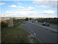
2
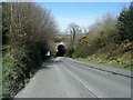
Hillhead Road goes under the Falmouth railway line
Image: © Colin Pyle
Taken: 9 Apr 2010
0.11 miles
5
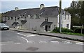
Saracen Way houses, Penryn
At the eastern end of Saracen Way, near Penryn Surgery. http://www.geograph.org.uk/photo/4703057
Image: © Jaggery
Taken: 16 Oct 2015
0.14 miles
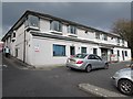
6
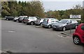
Penryn Surgery car park
At the eastern end of Saracen Way, the car park is for the use of patients visiting the surgery. http://www.geograph.org.uk/photo/4703057
Image: © Jaggery
Taken: 16 Oct 2015
0.15 miles
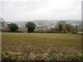
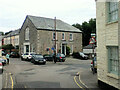
9
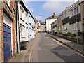
St Thomas Street in Penryn
Looking north-westward.
Image: © Peter Wood
Taken: 4 May 2017
0.16 miles
10
Penryn Surgery, Penryn
Medical surgery at the eastern end of Saracen Way.
Image: © Jaggery
Taken: 16 Oct 2015
0.17 miles