1
Penryn Town Hall
On a narrow island between Higher Market Street and Lower Market Street.
The Grade II* listed building was erected as a market hall in the 17th century.
The town clock is a later addition. The building was extended and remodelled in 1839.
Image: © Jaggery
Taken: 16 Oct 2015
0.00 miles
2
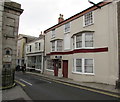
Penryn Barbers, Penryn
Town centre barber shop at 13 Higher Market Street, facing the Town Hall. http://www.geograph.org.uk/photo/4703064
Image: © Jaggery
Taken: 16 Oct 2015
0.00 miles
3
Town Hall, Higher Market Street, Penryn
Grade II* Listed market hall and later town clock and town lock-up. 17th century, extended and remodelled 1825 and 1839. The Town Hall is on the site of the pre-Reformation Church of St Mary. It is thought that some of the stone from the historic ecclesiastical Glasney College was used in its construction. The Town Hall was built on top of the Market House in 1823-5 and the clock tower added in the 1839.
Image: © Jo and Steve Turner
Taken: 30 Jun 2019
0.00 miles
4
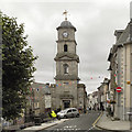
The Town Hall, Penrhyn
A very narrow town hall, squeezed into the middle of the road. It is hard to believe that this road was the A394.
Image: © Humphrey Bolton
Taken: 6 Jan 2016
0.01 miles
5
Penryn Town Hall
Higher Market Street.
Image: © David Dixon
Taken: 30 Jul 2010
0.01 miles
6
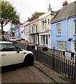
Town Mayor and Town Clerk parking spaces, Penryn
Reserved parking spaces in front of the town hall. http://www.geograph.org.uk/photo/4703064
The car is parked in the Town Clerk's parking space. The Town Mayor's parking space is vacant.
Image: © Jaggery
Taken: 16 Oct 2015
0.01 miles
7
Teetotal Hall, Lower Market Street, Penryn
Grade II Listed temperance hall with 1852 datestone.
Image: © Jo and Steve Turner
Taken: 30 Jun 2019
0.02 miles
8
Lloyds Bank, Penryn
The bank at 25 Higher Market Street is open for only 12 hours a week in October 2015.
Times displayed are 10am-2pm on Mondays, Wednesdays and Fridays.
Image: © Jaggery
Taken: 16 Oct 2015
0.02 miles
9
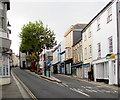
Higher Market Street and Lower Market Street, Penryn
Higher Market Street is on the left.
Image: © Jaggery
Taken: 16 Oct 2015
0.02 miles
10
Bilingual street name sign, Higher Market Street, Penryn
English and Cornish name sign on the corner of Higher Market Street and Saracen Place.
Image: © Jaggery
Taken: 16 Oct 2015
0.02 miles


