IMAGES TAKEN NEAR TO
Mount Pleasant, Old Road, TOTNES, TQ9 7TG
Introduction
This page details the photographs taken nearby to Mount Pleasant, Old Road, TQ9 7TG by members of the Geograph project.
The Geograph project started in 2005 with the aim of publishing, organising and preserving representative images for every square kilometre of Great Britain, Ireland and the Isle of Man.

There are currently over 7.5m images from over14,400 individuals and you can help contribute to the project by visiting https://www.geograph.org.uk
Image Map
Images are licensed for reuse under creativecommons.org/licenses/by-sa/2.0
Notes
- Clicking on the map will re-center to the selected point.
- The higher the marker number, the further away the image location is from the centre of the postcode.
Image Listing (56 Images Found)
Images are licensed for reuse under creativecommons.org/licenses/by-sa/2.0
Image
Details
Distance
1
Bow Road meets Old Road, Harbertonford
On the right is the Primitive Methodist Chapel, built 1900. Beneath each of the three windows to the street is a commemorative stone. The inscriptions read: "Laid by Mr L. Heath"; "Laid by Mr W. H. Box"; and "Laid by Mrs Leadbetter".
Image: © Robin Stott
Taken: 29 Jul 2010
0.04 miles
2
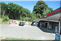
School entrance, Old Road, Harbertonford
This is the Harbertonford C. of E. (V.A.) Primary School.
Image: © Robin Stott
Taken: 29 Jul 2010
0.04 miles
3
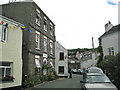
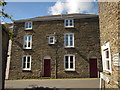
Ford House, Harbertonford
A view of Image from the other direction along Old Road. http://list.english-heritage.org.uk/resultsingle.aspx?uid=1108238&searchtype=mapsearch . Also listed is the K6 telephone box http://list.english-heritage.org.uk/resultsingle.aspx?uid=1216008&searchtype=mapsearch glimpsed along the street.
Image: © Derek Harper
Taken: 19 Sep 2012
0.07 miles
4
Ford House, Harbertonford
At the lower end of Old Road. Grade II listed. "Formerly and probably originally, an inn, now divided into 3 flats. Circa 1830s." http://www.britishlistedbuildings.co.uk/en-101350-ford-house-harberton The view from the other direction is Image
Image: © Robin Stott
Taken: 29 Jul 2010
0.07 miles
5
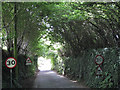
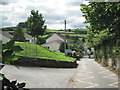
Old Road nearing Harbertonford
Through a tunnel of old coppiced hazel, a feature seen on the approach to some other villages.
Image: © Robin Stott
Taken: 29 Jul 2010
0.07 miles
8
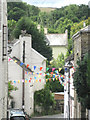
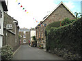
Bunting over Old Road, Harbertonford
Old Road climbs steeply south out of the village, affording eaves-level views back.
Image: © Robin Stott
Taken: 29 Jul 2010
0.08 miles
9
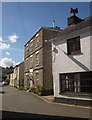
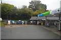
Old Bakery. Harbertonford
On Old Road, and seen from Bow Road.
Image: © Derek Harper
Taken: 19 Sep 2012
0.08 miles
10
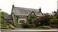
Old School, Harbertonford
Also shown in Image, the former school on the A381 is listed https://historicengland.org.uk/listing/the-list/list-entry/1108231 : "Erected in 1848 by vicar of Harberton, Chancellor Martin ... with extensions added in 1881, converted into house ... Tudor style ... Large 5-light granite window either side with 4-centred headed lights and hoodmould, the mullions replaced with concrete replacements".
Image: © Derek Harper
Taken: 12 Aug 2018
0.08 miles