IMAGES TAKEN NEAR TO
Harbertonford, TOTNES, TQ9 7ST
Introduction
This page details the photographs taken nearby to TQ9 7ST by members of the Geograph project.
The Geograph project started in 2005 with the aim of publishing, organising and preserving representative images for every square kilometre of Great Britain, Ireland and the Isle of Man.

There are currently over 7.5m images from over14,400 individuals and you can help contribute to the project by visiting https://www.geograph.org.uk
Image Map
Images are licensed for reuse under creativecommons.org/licenses/by-sa/2.0
Notes
- Clicking on the map will re-center to the selected point.
- The higher the marker number, the further away the image location is from the centre of the postcode.
Image Listing (23 Images Found)
Images are licensed for reuse under creativecommons.org/licenses/by-sa/2.0
Image
Details
Distance
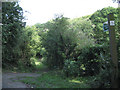
1
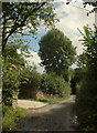
Lane at Dattins
Image: © Derek Harper
Taken: 26 Aug 2020
0.01 miles
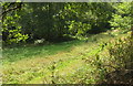
2
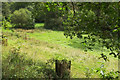
Meadow by Ashwell Brook
By the lane from Crabadon.
Image: © Derek Harper
Taken: 26 Aug 2020
0.05 miles
3
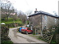
Dattins
Or Dottins, according to the OS map, but nothing else. Interesting gothic windows in the obviously-altered roadside cottage below the farmhouse - could it once have had some religious use? Seen looking north-east.
Image: © Derek Harper
Taken: 11 Apr 2006
0.05 miles
4
Ashwell Brook near Dottins
Steep hillsides plummet to the brook on each side.
Image: © Robin Stott
Taken: 29 Jul 2010
0.06 miles
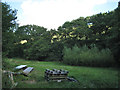
5

Lane at Dattins
West of the farm, the lane goes through a tunnel of trees.
Image: © Derek Harper
Taken: 26 Aug 2020
0.07 miles
6
Meadow by Ashwell Brook
Looking right from Image
Image: © Derek Harper
Taken: 26 Aug 2020
0.08 miles
7
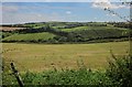
Towards Ashwell
Apart from one barn, the farming hamlet of Ashwell is entirely hidden by trees. It lies across the valley of the Ashwell Brook.
Image: © Derek Harper
Taken: 6 Aug 2015
0.11 miles
8
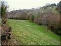
Meadow by Ashwell Brook
A view from the lane near Dottin's.
Image: © Derek Harper
Taken: 11 Apr 2006
0.11 miles
9
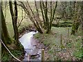
Ashwell Brook
Looking upstream near Dorrin's Quarry.
Image: © Derek Harper
Taken: 11 Apr 2006
0.14 miles
10
Unmetalled road to Ashwell
It crosses the Ashwell Brook then climbs steeply round to the right among trees.
Image: © Robin Stott
Taken: 29 Jul 2010
0.14 miles