IMAGES TAKEN NEAR TO
East Allington, TOTNES, TQ9 7QD
Introduction
This page details the photographs taken nearby to TQ9 7QD by members of the Geograph project.
The Geograph project started in 2005 with the aim of publishing, organising and preserving representative images for every square kilometre of Great Britain, Ireland and the Isle of Man.

There are currently over 7.5m images from over14,400 individuals and you can help contribute to the project by visiting https://www.geograph.org.uk
Image Map (Loading...)


Getting Data...Please wait
Leaflet Map data © OpenStreetMap
Images are licensed for reuse under creativecommons.org/licenses/by-sa/2.0
Notes
- Clicking on the map will re-center to the selected point.
- The higher the marker number, the further away the image location is from the centre of the postcode.
Image Listing (6 Images Found)
Images are licensed for reuse under creativecommons.org/licenses/by-sa/2.0
Image
Details
Distance
1
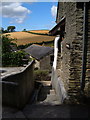
Pitt Farm
Two of the converted outbuildings at Pitt Farm near East Allington.
Image: © Derek Harper
Taken: 28 Jul 2006
0.01 miles
2
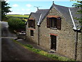
Converted building at Pitt Farm
A smart conversion (now called Martingale) of a farm outbuilding at Pitt Farm north of East Allington. The bridleway to the village passes by on the left.
Image: © Derek Harper
Taken: 28 Jul 2006
0.01 miles
3
Pitt Farm
A farm near East Allington that has been extensively developed for tourism accommodation, with indoor pool and tennis court.
Image: © Derek Harper
Taken: 28 Jul 2006
0.06 miles
4
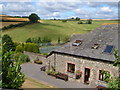
Pitt Farm
A converted outbuilding at this farm north of east Allington which offers superior holiday accommodation - note the tennis court. Beyond, the ground rises towards the ridgetop A381.
Image: © Derek Harper
Taken: 28 Jul 2006
0.06 miles
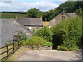
5
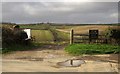
Gateway on Green Lane
At Pitt Farm, which is off to the right, along the bridleway to Cuttery and Chilley. The track across the valley is in Image
Image: © Derek Harper
Taken: 30 Jan 2013
0.13 miles
6
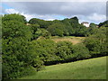
Cuttery House
Pink hilltop farmhouse near the A381 north of Kingsbridge; seen from the bridleway from Pitt Farm.
Image: © Derek Harper
Taken: 28 Jul 2006
0.23 miles