IMAGES TAKEN NEAR TO
Harberton, TOTNES, TQ9 7NE
Introduction
This page details the photographs taken nearby to TQ9 7NE by members of the Geograph project.
The Geograph project started in 2005 with the aim of publishing, organising and preserving representative images for every square kilometre of Great Britain, Ireland and the Isle of Man.

There are currently over 7.5m images from over14,400 individuals and you can help contribute to the project by visiting https://www.geograph.org.uk
Image Map
Images are licensed for reuse under creativecommons.org/licenses/by-sa/2.0
Notes
- Clicking on the map will re-center to the selected point.
- The higher the marker number, the further away the image location is from the centre of the postcode.
Image Listing (15 Images Found)
Images are licensed for reuse under creativecommons.org/licenses/by-sa/2.0
Image
Details
Distance
1
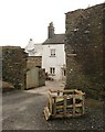
West Leigh
The old farmhouse glimpsed from the lane. See also Image
Image: © Derek Harper
Taken: 12 Feb 2009
0.01 miles
2
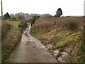
West Leigh
The lane from West Leigh Cross approaches the farm, some of whose outbuildings have been impressively renovated.
Image: © Derek Harper
Taken: 12 Feb 2009
0.02 miles
3
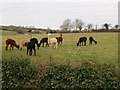
Alpacas at West Leigh
The paler the alpaca, the more interest they take in the passer-by. These are by the lane between Beenleigh and West Leigh Cross.
Image: © Derek Harper
Taken: 12 Feb 2009
0.07 miles
4
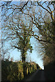
Lane to West Leigh
Climbing from Higher Beenleigh Bridge.
Image: © Derek Harper
Taken: 26 Feb 2019
0.08 miles
5
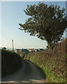
Lane to West Leigh
West Leigh, a farm with several converted buildings, can be seen ahead.
Image: © Derek Harper
Taken: 26 Feb 2019
0.10 miles
6

Sign, Westleigh Barton
This cheery tractor by the entrance shown in Image is, unfortunately, not seen from the Sunnyside, which is the name of a dwelling adjoining the farm.
Image: © Derek Harper
Taken: 26 Feb 2019
0.11 miles
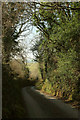
7
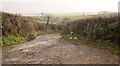
Lane at West Leigh Cross
Heading towards West Leigh Cross between hedgebanks.
Image: © Derek Harper
Taken: 26 Feb 2019
0.11 miles
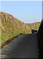
8
Lane to Higher Beenleigh Bridge
Looking in the opposite direction from where Image] was taken.
Image: © Derek Harper
Taken: 26 Feb 2019
0.11 miles
9
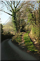
Field entrance near Beenleigh
The start of this ramped track can just be seen down the lane in Image The young wood it leads into goes unnamed on maps.
Image: © Derek Harper
Taken: 26 Feb 2019
0.12 miles
10
Entrance to Westleigh Barton
Mapped as Leigh Barton. An adjoining sign also shows this as the entrance to Sunnyside.
Image: © Derek Harper
Taken: 26 Feb 2014
0.12 miles