IMAGES TAKEN NEAR TO
Diptford, TOTNES, TQ9 7LZ
Introduction
This page details the photographs taken nearby to TQ9 7LZ by members of the Geograph project.
The Geograph project started in 2005 with the aim of publishing, organising and preserving representative images for every square kilometre of Great Britain, Ireland and the Isle of Man.

There are currently over 7.5m images from over14,400 individuals and you can help contribute to the project by visiting https://www.geograph.org.uk
Image Map
Images are licensed for reuse under creativecommons.org/licenses/by-sa/2.0
Notes
- Clicking on the map will re-center to the selected point.
- The higher the marker number, the further away the image location is from the centre of the postcode.
Image Listing (8 Images Found)
Images are licensed for reuse under creativecommons.org/licenses/by-sa/2.0
Image
Details
Distance
1
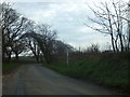
Road junction and signpost at Bradridge Cross
The junction is a slightly staggered crossroads
Image: © David Smith
Taken: 29 Mar 2014
0.14 miles
2
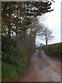
Mud on the road to Bradridge Farm
The road east from Bradridge Cross; the trees on the left screen the grounds of Bradridge House
Image: © David Smith
Taken: 29 Mar 2014
0.15 miles
3
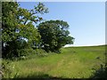
Trees and field, Diptford
The field on the left of Image The hedgerow trees disappear as the land rises.
Image: © Derek Harper
Taken: 24 Jun 2009
0.18 miles
4
Approaching Diptford
The lane from Diptford Green reaches the village sign by Diptford Court, though it is still 200 metres short of the main built-up area.
Image: © Derek Harper
Taken: 24 Jun 2009
0.20 miles
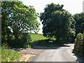
5
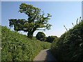
Lane near Diptford
Taken along the right-hand lane from the fork shown in Image, as it psses oak trees and approaches the junction with a side lane from Bradridge Cross.
Image: © Derek Harper
Taken: 24 Jun 2009
0.21 miles
6

Field near Christone Cross
From a gateway just left of Image
Image: © Derek Harper
Taken: 26 Aug 2020
0.22 miles
7
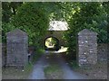
Drive to Diptford Court
Seen from the corner shown in Image, with an arch beneath an outbuilding to the C16 former farmhouse.
Image: © Derek Harper
Taken: 24 Jun 2009
0.23 miles
8
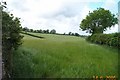
Diptford field
A typical field in this richly agricultural area.
Image: © Richard Knights
Taken: 14 Jun 2005
0.25 miles