IMAGES TAKEN NEAR TO
Harberton, TOTNES, TQ9 7LW
Introduction
This page details the photographs taken nearby to TQ9 7LW by members of the Geograph project.
The Geograph project started in 2005 with the aim of publishing, organising and preserving representative images for every square kilometre of Great Britain, Ireland and the Isle of Man.

There are currently over 7.5m images from over14,400 individuals and you can help contribute to the project by visiting https://www.geograph.org.uk
Image Map
Images are licensed for reuse under creativecommons.org/licenses/by-sa/2.0
Notes
- Clicking on the map will re-center to the selected point.
- The higher the marker number, the further away the image location is from the centre of the postcode.
Image Listing (7 Images Found)
Images are licensed for reuse under creativecommons.org/licenses/by-sa/2.0
Image
Details
Distance
1
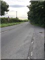
Higher Plymouth Road
Close to Blue Post, heading towards Totnes.
Image: © jeff collins
Taken: 26 Jul 2020
0.12 miles
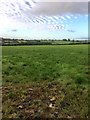
3
Rushy field, Gosworthy Farm
From the Totnes - Avonwick Road. The valley it slopes down to is of a tributary of the Harbourn River.
Image: © Derek Harper
Taken: 8 May 2017
0.14 miles
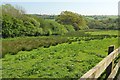
4
Road to Totnes
A relatively fast road that links Avonwick, and therefore the A38, to Totnes, seen from the place where Image] was taken.
Image: © Derek Harper
Taken: 8 May 2017
0.15 miles
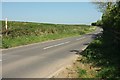
5
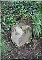
Old Milestone by the former B3210, near Blue Post Garage, Harberton parish
Carved stone post by the UC road (was B3210), in parish of HARBERTON (SOUTH HAMS District), 50m East of Blue Post Garage, opposite Blue Post Cottages, on grass verge, close to road, by telegraph pole, on South side of road. Totnes granite marker, erected by the Totnes & Bridgetown-Pomeroy turnpike trust in the 18th century.
Inscription reads:-
: To / Plym_th / 18 / (Miles) : : To / Totnes / 4 / (Miles) :
Grade II listed.
List Entry Number: 1108251 https://historicengland.org.uk/listing/the-list/list-entry/1108251
Milestone Society National ID: DV_PLTN18
Image: © Alan Rosevear
Taken: 5 Apr 2012
0.16 miles
6
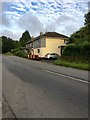
Houses at Blue Post
Seen looking across the Higher Plymouth Road.
Image: © jeff collins
Taken: 26 Jul 2020
0.17 miles
7
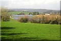
Solar farm, Blue Post
A zoomed view of the solar farm from the same gate as Image], and a detail of that image. The houses on the right are Bluepost Farm and Cottage. On the horizon is Dartmoor.
Image: © Derek Harper
Taken: 26 Feb 2014
0.24 miles