IMAGES TAKEN NEAR TO
Blackawton, TOTNES, TQ9 7AE
Introduction
This page details the photographs taken nearby to TQ9 7AE by members of the Geograph project.
The Geograph project started in 2005 with the aim of publishing, organising and preserving representative images for every square kilometre of Great Britain, Ireland and the Isle of Man.

There are currently over 7.5m images from over14,400 individuals and you can help contribute to the project by visiting https://www.geograph.org.uk
Image Map
Images are licensed for reuse under creativecommons.org/licenses/by-sa/2.0
Notes
- Clicking on the map will re-center to the selected point.
- The higher the marker number, the further away the image location is from the centre of the postcode.
Image Listing (32 Images Found)
Images are licensed for reuse under creativecommons.org/licenses/by-sa/2.0
Image
Details
Distance


9
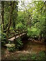
Bridge across The Gara
Here The Gara is crossed just upstream of Millcombe by Blackawton Footpath 15, a stretch of path scarcely more than 70 metres in length.
Image: © Derek Harper
Taken: 23 May 2009
0.07 miles
