
IMAGES TAKEN NEAR TO
Longcombe, TOTNES, TQ9 6PR
Introduction
This page details the photographs taken nearby to TQ9 6PR by members of the Geograph project.
The Geograph project started in 2005 with the aim of publishing, organising and preserving representative images for every square kilometre of Great Britain, Ireland and the Isle of Man.

There are currently over 7.5m images from over14,400 individuals and you can help contribute to the project by visiting https://www.geograph.org.uk
Image Map
Images are licensed for reuse under creativecommons.org/licenses/by-sa/2.0
Notes
- Clicking on the map will re-center to the selected point.
- The higher the marker number, the further away the image location is from the centre of the postcode.
Image Listing (20 Images Found)
Images are licensed for reuse under creativecommons.org/licenses/by-sa/2.0
Image
Details
Distance
1
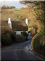
Parliament, Longcombe
A corner of the C17 cottages where "William Prince of Orange is said to have held his first Parliament ... in November 1688", as explained in the detailed architectural record at https://historicengland.org.uk/listing/the-list/list-entry/1166343. Looking down the lane from Aish.
Image: © Derek Harper
Taken: 25 Jan 2009
0.00 miles
2
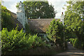
Parliament, Longcombe
"William Prince of Orange is said to have held his first Parliament here in November 1688" https://historicengland.org.uk/listing/the-list/list-entry/1166343 . See also https://www.geograph.org.uk/gridref/SX8359?centi=SX836596 ; the condition of the building has deteriorated considerably from earlier photos.
Image: © Derek Harper
Taken: 19 Jul 2020
0.00 miles
3
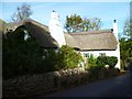
Orange Way in Devon and Torbay (47)
This residence is Parliament and is where Prince William of Orange held his first Council Meeting. There is a commemorative stone at Image
Image: © Shazz
Taken: 18 Oct 2011
0.01 miles
4
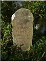
Orange Way in Devon and Torbay (48)
This stone commemorates Prince William of Orange's first "parliament". The building is at Image
Image: © Shazz
Taken: 18 Oct 2011
0.01 miles
5
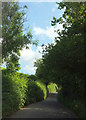
Lane near Parliament
Parliament is just round the corner. See https://www.geograph.org.uk/gridref/SX8359?centi=SX836596 .
Image: © Derek Harper
Taken: 19 Jul 2020
0.02 miles
6
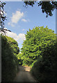
Lane junction near Parliament
The no through road from Fleet Mill meets the lane between Longcombe Cross and Aish.
Image: © Derek Harper
Taken: 19 Jul 2020
0.09 miles
7
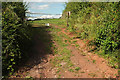
Gate near Parliament
Many gates around here have the same message: "PRIVATE PROPERTY KEEP OUT". One has a rude response written on it.
Image: © Derek Harper
Taken: 19 Jul 2020
0.10 miles
8
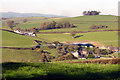
Longcombe farm and Longcombe Cross
Viewpoint south of Longcombe towards Longcombe, middle distance. Haytor, on eastern Dartmoor, is visible on the extreme left horizon
Image: © Crispin Purdye
Taken: 17 Nov 2005
0.12 miles
9
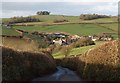
Longcombe from the south
A similar view to Image and Image, from a slightly lower viewpoint down the lane approaching the hamlet from Aish.
Image: © Derek Harper
Taken: 25 Jan 2009
0.12 miles
10
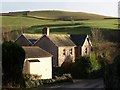
House at Longcombe
In the foreground is the junction of the lane descending from Longcombe Cross and Glazegate Lane (left). The lane continues to Aish. The summit of the hill behind appears in Image
Image: © Derek Harper
Taken: 25 Jan 2009
0.15 miles