IMAGES TAKEN NEAR TO
Longcombe, TOTNES, TQ9 6PP
Introduction
This page details the photographs taken nearby to TQ9 6PP by members of the Geograph project.
The Geograph project started in 2005 with the aim of publishing, organising and preserving representative images for every square kilometre of Great Britain, Ireland and the Isle of Man.

There are currently over 7.5m images from over14,400 individuals and you can help contribute to the project by visiting https://www.geograph.org.uk
Image Map (Loading...)


Getting Data...Please wait
Leaflet Map data © OpenStreetMap
Images are licensed for reuse under creativecommons.org/licenses/by-sa/2.0
Notes
- Clicking on the map will re-center to the selected point.
- The higher the marker number, the further away the image location is from the centre of the postcode.
Image Listing (8 Images Found)
Images are licensed for reuse under creativecommons.org/licenses/by-sa/2.0
Image
Details
Distance
1
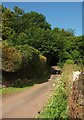
Lane at Lower Longcombe
Image: © Derek Harper
Taken: 5 Jul 2017
0.01 miles
2
Field, Lower Longcombe
On the left is the valley shown in Image and Image; the latter also shows the tree in the field. The lane ends at Fleet Mill.
Image: © Derek Harper
Taken: 19 Jul 2020
0.03 miles
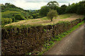
3

Valley, Lower Longcombe
A similar view, nine years on, to Image taken from the same place; this one looks a little more to the left. Vegetation has certainly grown over the years.
Image: © Derek Harper
Taken: 5 Jul 2017
0.08 miles
4

Weathercare House
By the no through lane to Fleet Mill.
Image: © Derek Harper
Taken: 19 Jul 2020
0.10 miles
5
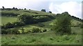
Hillside, Longcombe
A view across the valley near Lower Longcombe from the lane down to Fleet Mill.
Image: © Derek Harper
Taken: 7 Aug 2008
0.11 miles
6
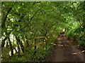
Lane near Longcombe
The lane below Lower Longcombe crosses the easting gridline just along here. On the left of the tunnel of greenery, below the fence, is the stream that passes Fleet Mill on its way to the River Dart.
Image: © Derek Harper
Taken: 7 Aug 2008
0.18 miles
7
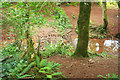
Longcombe Stream
Just below the lane from Lower Longcombe to Fleet Mill.
Image: © Derek Harper
Taken: 19 Jul 2020
0.24 miles
8
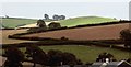
Farmland east of Totnes
A view across hilly fields near Longcombe, from Kingsbridge Hill, over the roofs of new housing
Image: © Derek Harper
Taken: 9 Aug 2017
0.24 miles