IMAGES TAKEN NEAR TO
Lower Collins Road, TOTNES, TQ9 5PS
Introduction
This page details the photographs taken nearby to Lower Collins Road, TQ9 5PS by members of the Geograph project.
The Geograph project started in 2005 with the aim of publishing, organising and preserving representative images for every square kilometre of Great Britain, Ireland and the Isle of Man.

There are currently over 7.5m images from over14,400 individuals and you can help contribute to the project by visiting https://www.geograph.org.uk
Image Map
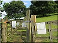
Images are licensed for reuse under creativecommons.org/licenses/by-sa/2.0
Notes
- Clicking on the map will re-center to the selected point.
- The higher the marker number, the further away the image location is from the centre of the postcode.
Image Listing (564 Images Found)
Images are licensed for reuse under creativecommons.org/licenses/by-sa/2.0
Image
Details
Distance
1
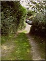
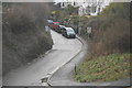
Track to Collins Road, Totnes
Looking in the opposite direction from where Image] was taken.
Image: © Derek Harper
Taken: 26 Aug 2017
0.01 miles
2
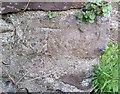
Ordnance Survey Cut Mark
This OS cut mark can be found on the wall east side of Collins Road. It marks a point 11.211m above mean sea level.
Image: © Adrian Dust
Taken: 25 Mar 2019
0.01 miles
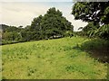
3
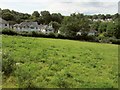
Castle Meadow, Totnes
Image: © Derek Harper
Taken: 26 Aug 2017
0.01 miles
4
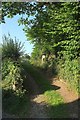
Entrance to Castle Meadow, Totnes
A reverse view of Image], with the steep track from Collins Road that also leads to the allotments shown in Image
Image: © Derek Harper
Taken: 27 Aug 2017
0.01 miles
5
Entrance to Castle Meadow, Totnes
Just to the right of the allotments entrance shown in Image Castle Meadow is a sheep pasture on the hillside above Collins Road. It's also bang in the middle of Totnes.
Image: © Derek Harper
Taken: 26 Aug 2017
0.02 miles
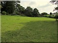
6
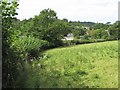
Castle Meadow, Totnes
The western edge of the sheep pasture in the middle of town.
Image: © Derek Harper
Taken: 26 Aug 2017
0.02 miles
7
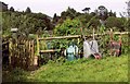
Allotments on Collins Road, Totnes
The entrance to Castle Meadow Allotments, with three wheelbarrows awaiting use.
Image: © Derek Harper
Taken: 26 Aug 2017
0.02 miles
9
Castle Meadow, Totnes
Another view of the sheep pasture shown in Image
Image: © Derek Harper
Taken: 26 Aug 2017
0.03 miles
10
Castle Meadow, Totnes
Opening this hillside sheep pasture (owned since 1983 by Totnes Council) to the public has been the subject of controversy, but it is now open during the day.
Image: © Derek Harper
Taken: 26 Aug 2017
0.03 miles