IMAGES TAKEN NEAR TO
Somerset Place, TOTNES, TQ9 5AX
Introduction
This page details the photographs taken nearby to Somerset Place, TQ9 5AX by members of the Geograph project.
The Geograph project started in 2005 with the aim of publishing, organising and preserving representative images for every square kilometre of Great Britain, Ireland and the Isle of Man.

There are currently over 7.5m images from over14,400 individuals and you can help contribute to the project by visiting https://www.geograph.org.uk
Image Map (Loading...)


Getting Data...Please wait
Leaflet Map data © OpenStreetMap
Images are licensed for reuse under creativecommons.org/licenses/by-sa/2.0
Notes
- Clicking on the map will re-center to the selected point.
- The higher the marker number, the further away the image location is from the centre of the postcode.
Image Listing (277 Images Found)
Images are licensed for reuse under creativecommons.org/licenses/by-sa/2.0
Image
Details
Distance
1
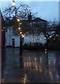
Lights, Rotherfold, Totnes
Christmas lights adorn the little square at the top of town. At the rear are buildings on Cistern Street.
Image: © Derek Harper
Taken: 19 Dec 2019
0.02 miles
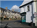
3
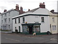
Bridgetown Stores, Totnes
At 14-15 Bridgetown, on the corner of Seymour Place.
Image: © Jaggery
Taken: 5 Jul 2014
0.04 miles
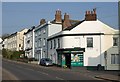
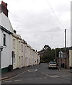
4
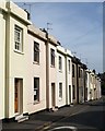
Seymour Place, Totnes
A terrace of 10 houses leading away from Bridgetown in Totnes.
Image: © Derek Harper
Taken: 10 May 2008
0.04 miles
5
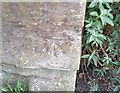
Ordnance Survey Cut Mark
This OS cut mark can be found on the wall of No19 Bridgetown Hill. It marks a point 13.593m above mean sea level.
Image: © Adrian Dust
Taken: 25 Mar 2019
0.04 miles
7
Bridgetown
The old main road on the east side of Totnes Bridge passes the junction with Seymour Place. See also Image
Image: © Derek Harper
Taken: 8 Mar 2011
0.04 miles
8
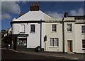
Corner shop, Bridgetown
The "Earlier-mid C19 corner shop" is described at https://www.historicengland.org.uk/listing/the-list/list-entry/1107499 and also seen in Image, Image, Image and Image
Image: © Derek Harper
Taken: 28 Feb 2016
0.04 miles
9
Seymour Place, Totnes
Looking south from opposite Bridgetown Stores. http://www.geograph.org.uk/photo/4065289
Image: © Jaggery
Taken: 5 Jul 2014
0.04 miles
10
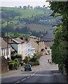
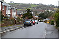
Bridgetown Hill, Totnes
Brakes on for the sharp bend at the bottom of the hill. Ahead is Bridgetown itself, bending right past St John's Church. Across the Dart valley are houses on Totnes Down Hill.
Image: © Derek Harper
Taken: 10 May 2008
0.05 miles