IMAGES TAKEN NEAR TO
Woodbrook Road, TOTNES, TQ9 5AS
Introduction
This page details the photographs taken nearby to Woodbrook Road, TQ9 5AS by members of the Geograph project.
The Geograph project started in 2005 with the aim of publishing, organising and preserving representative images for every square kilometre of Great Britain, Ireland and the Isle of Man.

There are currently over 7.5m images from over14,400 individuals and you can help contribute to the project by visiting https://www.geograph.org.uk
Image Map (Loading...)


Getting Data...Please wait
Leaflet Map data © OpenStreetMap
Images are licensed for reuse under creativecommons.org/licenses/by-sa/2.0
Notes
- Clicking on the map will re-center to the selected point.
- The higher the marker number, the further away the image location is from the centre of the postcode.
Image Listing (182 Images Found)
Images are licensed for reuse under creativecommons.org/licenses/by-sa/2.0
Image
Details
Distance
3
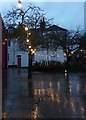
Lights, Rotherfold, Totnes
Christmas lights adorn the little square at the top of town. At the rear are buildings on Cistern Street.
Image: © Derek Harper
Taken: 19 Dec 2019
0.07 miles
4
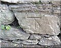
Ordnance Survey Cut Mark
This OS cut mark can be found on the wall SE side of Bridgetown Hill. It marks a point 19.858m above mean sea level.
Image: © Adrian Dust
Taken: 25 Mar 2019
0.07 miles
5

Barbary nut, Totnes
One of my favourite Mediterranean flowers, these irises are planted in a little flowerbed in Bridgetown. This hasn't come out as the right colour; they were richer and deeper than they appear here. I wonder if the flowers are as short-lived as they prove to be in their natural habitat.
Image: © Derek Harper
Taken: 18 Feb 2014
0.08 miles
6
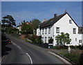
Bridgetown Hill, Totnes
A different angle on the view in Image, with the church of St John the Evangelist http://list.english-heritage.org.uk/resultsingle.aspx?uid=1325376&searchtype=mapsearch .
Image: © Derek Harper
Taken: 25 Aug 2013
0.08 miles
7
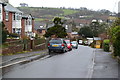
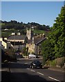
A385 at Bridgetown
The main road swings right towards the Brutus Bridge roundabout Image The route to Plymouth or Kingsbridge would, until 1982, have continued down through Bridgetown, the road the car is waiting to turn out of. Now most through traffic follows the bypass over Brutus Bridge.
Image: © Derek Harper
Taken: 17 Mar 2021
0.08 miles
8
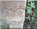
Ordnance Survey Cut Mark
This OS cut mark can be found on the wall of No19 Bridgetown Hill. It marks a point 13.593m above mean sea level.
Image: © Adrian Dust
Taken: 25 Mar 2019
0.08 miles
9
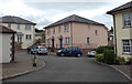
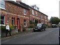
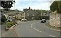
Varian Court, Bridgetown, Totnes
Modern houses in a cul-de-sac on the south side of the A385 Bridgetown Hill.
Image: © Jaggery
Taken: 5 Jul 2014
0.08 miles