IMAGES TAKEN NEAR TO
East Portlemouth, SALCOMBE, TQ8 8PU
Introduction
This page details the photographs taken nearby to TQ8 8PU by members of the Geograph project.
The Geograph project started in 2005 with the aim of publishing, organising and preserving representative images for every square kilometre of Great Britain, Ireland and the Isle of Man.

There are currently over 7.5m images from over14,400 individuals and you can help contribute to the project by visiting https://www.geograph.org.uk
Image Map (Loading...)


Getting Data...Please wait
Leaflet Map data © OpenStreetMap
Images are licensed for reuse under creativecommons.org/licenses/by-sa/2.0
Notes
- Clicking on the map will re-center to the selected point.
- The higher the marker number, the further away the image location is from the centre of the postcode.
Image Listing (90 Images Found)
Images are licensed for reuse under creativecommons.org/licenses/by-sa/2.0
Image
Details
Distance
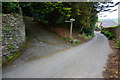
1
Ordnance Survey Cut Mark
This OS cut mark can be found on a stone gatepost NE side of the path. It marks a spot 41.874m above mean sea level.
Image: © Adrian Dust
Taken: 27 Mar 2019
0.06 miles
2
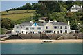
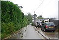
Ferry Side Cottages
East Portlemouth - next to the Ferry landing stage
Image: © Keith Lockstone
Taken: 18 Jun 2010
0.06 miles
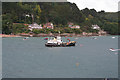
3
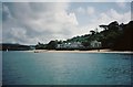
Small's Cove and the landing stage for the ferry to Salcombe
The houses on the Porthlemon side of the Salcombe inlet with the ferry landing stage across the sands.
Image: © David Stowell
Taken: Unknown
0.06 miles
4
Salcombe Harbour
Looking from Cliff Road to the waterside houses near Small's Cove on the opposite bank.
Image: © Kate Jewell
Taken: 29 Jul 2008
0.06 miles
5
Start of the footpath to East Portlemouth
The South West Coast Path follows the minor road ahead towards Mill Bay.
Image: © jeff collins
Taken: 5 Jun 2014
0.07 miles
6
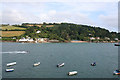
Small's Cove, Salcombe Harbour
The landing Stage for the Salcombe to East Portlemouth passenger ferry is just to the left of the large white building. Small's cove is to the right. At low tide there is quite an expanse of sand along the east bank of Salcombe Harbour. East Portlemouth is a small village just over the brow of the hill on the horizon.
View taken from Cliff Road, Salcombe, just above the Waterside Park.
Image: © Kate Jewell
Taken: 29 Jul 2008
0.07 miles
7
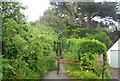
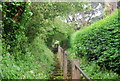
Steps to East Portlemouth
The steep climb from the ferry to the village.
Image: © N Chadwick
Taken: 7 Jun 2012
0.08 miles
9
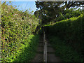
Steps to East Portlemouth
From the ferry to the parking area.
Image: © Hugh Venables
Taken: 11 Apr 2017
0.08 miles