IMAGES TAKEN NEAR TO
East Portlemouth, SALCOMBE, TQ8 8PN
Introduction
This page details the photographs taken nearby to TQ8 8PN by members of the Geograph project.
The Geograph project started in 2005 with the aim of publishing, organising and preserving representative images for every square kilometre of Great Britain, Ireland and the Isle of Man.

There are currently over 7.5m images from over14,400 individuals and you can help contribute to the project by visiting https://www.geograph.org.uk
Image Map (Loading...)


Getting Data...Please wait
Leaflet Map data © OpenStreetMap
Images are licensed for reuse under creativecommons.org/licenses/by-sa/2.0
Notes
- Clicking on the map will re-center to the selected point.
- The higher the marker number, the further away the image location is from the centre of the postcode.
Image Listing (14 Images Found)
Images are licensed for reuse under creativecommons.org/licenses/by-sa/2.0
Image
Details
Distance
2
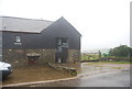
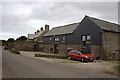
Converted barn, High House Farm
An attractive conversion, also shown in Image, with slate and stone facade, east of the farmhouse shown in Image
Image: © Derek Harper
Taken: 29 Nov 2010
0.01 miles
4
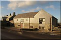
High House Farm
An old farmhouse and buildings now converted to holiday accommodation.
Image: © Tony Atkin
Taken: 5 Sep 2009
0.02 miles
5
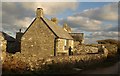
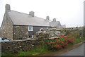
High House Farm
Four chimney stacks line up along the ridge of the C17 farmhouse http://www.britishlistedbuildings.co.uk/en-100718-high-house-farmhouse-east-portlemouth . "This house not only retains an interesting and unspoilt exterior but also preserves a number of early features inside."
Image: © Derek Harper
Taken: 29 Nov 2010
0.02 miles
6
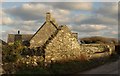
High House Farm
The gable of a ruin at the west end of the cluster of buildings at High House Farm.
Image: © Derek Harper
Taken: 29 Nov 2010
0.03 miles
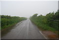
7
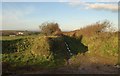
Track to Holset
A green lane with public access linking the ridge road between East Portlemouth and East Prawle with the lane down the valley from Holset (glimpsed on the left, and in Image) to Goodshelter.
Image: © Derek Harper
Taken: 29 Nov 2010
0.07 miles
9
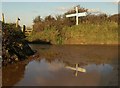
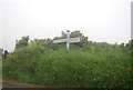
Rickham Cross
The signpost reflected in a puddle at the T-junction. On the left, a fingerpost points the start, through the gate, of East Portlemouth Footpath 20 to nearby Holset.
Image: © Derek Harper
Taken: 29 Nov 2010
0.12 miles