IMAGES TAKEN NEAR TO
Cross Lane, SALCOMBE, TQ8 8PB
Introduction
This page details the photographs taken nearby to Cross Lane, TQ8 8PB by members of the Geograph project.
The Geograph project started in 2005 with the aim of publishing, organising and preserving representative images for every square kilometre of Great Britain, Ireland and the Isle of Man.

There are currently over 7.5m images from over14,400 individuals and you can help contribute to the project by visiting https://www.geograph.org.uk
Image Map (Loading...)


Getting Data...Please wait
Leaflet Map data © OpenStreetMap
Images are licensed for reuse under creativecommons.org/licenses/by-sa/2.0
Notes
- Clicking on the map will re-center to the selected point.
- The higher the marker number, the further away the image location is from the centre of the postcode.
Image Listing (67 Images Found)
Images are licensed for reuse under creativecommons.org/licenses/by-sa/2.0
Image
Details
Distance
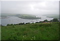
2
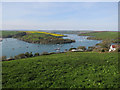
View over Kingsbridge Estuary
From the path down to the ferry to Salcombe.
Image: © Hugh Venables
Taken: 11 Apr 2017
0.08 miles
9

Northward view over Kingsbridge Estuary, from East Portlemouth, 1995
Below is the little ferry to Salcombe, which is round to the left. Kingsbridge is seen in the middle distance and Dartmoor is on the far horizon. Many rich people escape here to their second homes and their yachts.
Image: © Ben Brooksbank
Taken: 21 Apr 1995
0.13 miles