IMAGES TAKEN NEAR TO
Camperdown Road, SALCOMBE, TQ8 8BN
Introduction
This page details the photographs taken nearby to Camperdown Road, TQ8 8BN by members of the Geograph project.
The Geograph project started in 2005 with the aim of publishing, organising and preserving representative images for every square kilometre of Great Britain, Ireland and the Isle of Man.

There are currently over 7.5m images from over14,400 individuals and you can help contribute to the project by visiting https://www.geograph.org.uk
Image Map (11 Images)


Getting Data...Please wait
Leaflet Map data © OpenStreetMap
Images are licensed for reuse under creativecommons.org/licenses/by-sa/2.0
Notes
- Clicking on the map will re-center to the selected point.
- The higher the marker number, the further away the image location is from the centre of the postcode.
Image Listing (11 Images Found)
Images are licensed for reuse under creativecommons.org/licenses/by-sa/2.0
Image
Details
Distance
1
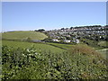
Beadon
View of Beadon housing estate
Image: © Richard Weymouth
Taken: 25 Aug 2004
0.09 miles
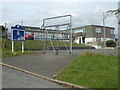
3
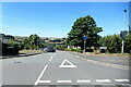
Salcombe : Beadon Road
Beadon Road off Main Road.
Image: © Lewis Clarke
Taken: 8 Jun 2021
0.11 miles
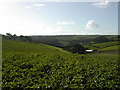
4
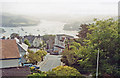
Salcombe, 1991: view over Harbour
View NE from Trennels Hotel, Herbert St.
Image: © Ben Brooksbank
Taken: 9 Jun 1991
0.17 miles
5
Salcombe Church of England Primary School
Image: © Chris Allen
Taken: 20 Jul 2017
0.18 miles
7
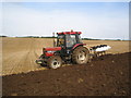
Ploughing in Salcombe
When everyone is on the beach enjoying themselves the farm work continues....
Image: © Richard Weymouth
Taken: 9 Sep 2004
0.23 miles
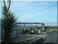
8
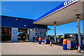
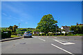
Salcombe : Gulf Petrol Station
A Gulf garage off Main Road.
Image: © Lewis Clarke
Taken: 8 Jun 2021
0.23 miles
10
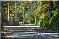
Salcombe : A381
Looking along the A381.
Image: © Lewis Clarke
Taken: 8 Jun 2021
0.24 miles