IMAGES TAKEN NEAR TO
Morgans Row, KINGSBRIDGE, TQ7 4PW
Introduction
This page details the photographs taken nearby to Morgans Row, TQ7 4PW by members of the Geograph project.
The Geograph project started in 2005 with the aim of publishing, organising and preserving representative images for every square kilometre of Great Britain, Ireland and the Isle of Man.

There are currently over 7.5m images from over14,400 individuals and you can help contribute to the project by visiting https://www.geograph.org.uk
Image Map (Loading...)


Getting Data...Please wait
Leaflet Map data © OpenStreetMap
Images are licensed for reuse under creativecommons.org/licenses/by-sa/2.0
Notes
- Clicking on the map will re-center to the selected point.
- The higher the marker number, the further away the image location is from the centre of the postcode.
Image Listing (49 Images Found)
Images are licensed for reuse under creativecommons.org/licenses/by-sa/2.0
Image
Details
Distance
1
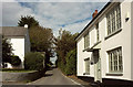
Houses at Kingston Plain
On the right is Pounds Farmhouse, on the left Trebles Cottage.
Image: © Derek Harper
Taken: 3 Oct 2019
0.06 miles
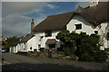
2
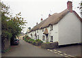
Honeysuckle Cottage Nos 1 to 5
This pictursque row of 17th &18th and 19th C. cottages are listed collectively as Grade II with English Heritage Building ID: 99618. there is more information at http://www.britishlistedbuildings.co.uk/en-99618-honeysuckle-cottage-nos-1-to-5-consecutive
Image: © Stuart Logan
Taken: 7 Oct 2013
0.06 miles
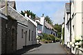
4
Village Street, Kingston
A reverse view of Image, with the thatched cottages of Chapel Row on the right. http://www.imagesofengland.org.uk/details/default.aspx?id=99618 Only the tip of the gable of the former chapel that gives them their name can be seen.
Image: © Derek Harper
Taken: 24 Sep 2009
0.06 miles
5

Ordnance Survey Cut Mark
This OS cut mark can be found on the front of the chapel. It marks a point 90.770m above mean sea level.
Image: © Adrian Dust
Taken: 26 Mar 2019
0.07 miles
6
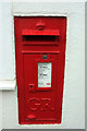
Postbox, Kingston
Look very carefully at Image and you can just make out this George V postbox (TQ7 67) on the right just beyond the black downpipe.
Image: © Derek Harper
Taken: 3 Oct 2019
0.08 miles
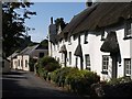
7
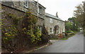
Langs, Kingston
Two houses on the village street as it climbs towards Kingston Plain.
Image: © Derek Harper
Taken: 3 Oct 2019
0.08 miles
8
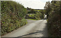
Lane approaching Kingston Plain
Passing Cherrytree Close.
Image: © Derek Harper
Taken: 3 Oct 2019
0.11 miles
9
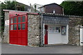
Kingston Fire Station
Kingston Fire Station, The Village, Kingston, Devon.
Image: © Kevin Hale
Taken: 4 Oct 2003
0.12 miles
10
The Old Forge, Kingston
Listed and described at https://historicengland.org.uk/listing/the-list/list-entry/1108107 . Also shown in Image
Image: © Derek Harper
Taken: 3 Oct 2019
0.13 miles