IMAGES TAKEN NEAR TO
Bridge End, Aveton Gifford, KINGSBRIDGE, TQ7 4NU
Introduction
This page details the photographs taken nearby to TQ7 4NU by members of the Geograph project.
The Geograph project started in 2005 with the aim of publishing, organising and preserving representative images for every square kilometre of Great Britain, Ireland and the Isle of Man.

There are currently over 7.5m images from over14,400 individuals and you can help contribute to the project by visiting https://www.geograph.org.uk
Image Map
Images are licensed for reuse under creativecommons.org/licenses/by-sa/2.0
Notes
- Clicking on the map will re-center to the selected point.
- The higher the marker number, the further away the image location is from the centre of the postcode.
Image Listing (62 Images Found)
Images are licensed for reuse under creativecommons.org/licenses/by-sa/2.0
Image
Details
Distance
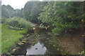
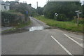
3
Bridge over stream at Bridge End, Aveton Gifford
Image: © David Smith
Taken: 23 Jul 2018
0.03 miles
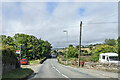
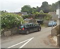
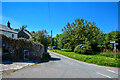
5
Bridge End
A small group of houses South of Aveton Gifford on the A379.
Image: © jeff collins
Taken: 6 Aug 2014
0.03 miles
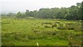
6
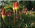
Red hot pokers, Bridge End
Where the Avon Estuary Walk meets the A379 at the southern end of Aveton Gifford Bridge.
Image: © Derek Harper
Taken: 22 May 2018
0.03 miles
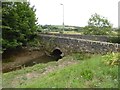
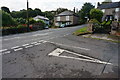
8
Aveton Gifford : Bridge End
A road off the A379.
Image: © Lewis Clarke
Taken: 8 Jun 2021
0.04 miles
9
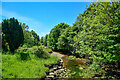
Aveton Gifford : Stream
A small stream.
Image: © Lewis Clarke
Taken: 8 Jun 2021
0.04 miles