IMAGES TAKEN NEAR TO
Aveton Gifford, KINGSBRIDGE, TQ7 4NL
Introduction
This page details the photographs taken nearby to TQ7 4NL by members of the Geograph project.
The Geograph project started in 2005 with the aim of publishing, organising and preserving representative images for every square kilometre of Great Britain, Ireland and the Isle of Man.

There are currently over 7.5m images from over14,400 individuals and you can help contribute to the project by visiting https://www.geograph.org.uk
Image Map
Images are licensed for reuse under creativecommons.org/licenses/by-sa/2.0
Notes
- Clicking on the map will re-center to the selected point.
- The higher the marker number, the further away the image location is from the centre of the postcode.
Image Listing (5 Images Found)
Images are licensed for reuse under creativecommons.org/licenses/by-sa/2.0
Image
Details
Distance
1
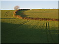
Tramlines in fields near Ashford
Lines picked out in the afternoon sun, seen from the lane to Hingston Borough. Not sure what crop this is.
Image: © Derek Harper
Taken: 4 Nov 2006
0.19 miles
2
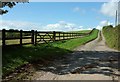
Farm track to Tetwell
Seen from where it leaves the lane between Combe Cross and Ashford. Not a right of way.
Image: © Derek Harper
Taken: 27 Aug 2015
0.20 miles
3
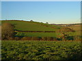
Balloon over Ashford
Fields to the west of the hamlet of Ashford, in afternoon sunlight.
Image: © Derek Harper
Taken: 4 Nov 2006
0.23 miles
4
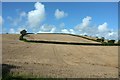
Hillside, Ashford
A late summer, and wider, view of the autumn scene in Image, from the lane west of Ashford.
Image: © Derek Harper
Taken: 27 Aug 2015
0.23 miles
5
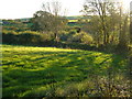
Field at Stoverlake
Aveton Gifford Footpath 12 begins in this field by the lane from Stoverlake to Ashford.
Image: © Derek Harper
Taken: 4 Nov 2006
0.24 miles