IMAGES TAKEN NEAR TO
Icy Park, KINGSBRIDGE, TQ7 4LQ
Introduction
This page details the photographs taken nearby to Icy Park, TQ7 4LQ by members of the Geograph project.
The Geograph project started in 2005 with the aim of publishing, organising and preserving representative images for every square kilometre of Great Britain, Ireland and the Isle of Man.

There are currently over 7.5m images from over14,400 individuals and you can help contribute to the project by visiting https://www.geograph.org.uk
Image Map (Loading...)


Getting Data...Please wait
Leaflet Map data © OpenStreetMap
Images are licensed for reuse under creativecommons.org/licenses/by-sa/2.0
Notes
- Clicking on the map will re-center to the selected point.
- The higher the marker number, the further away the image location is from the centre of the postcode.
Image Listing (23 Images Found)
Images are licensed for reuse under creativecommons.org/licenses/by-sa/2.0
Image
Details
Distance
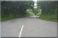
1
Approaching Aveton Gifford on the A379 in 1985
This was the route of the A379 before the bypass was constructed.
Image: © John Baker
Taken: 24 Mar 1985
0.06 miles
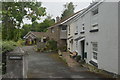
2
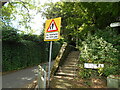
Steps to Icy park
Steps and a foot path avoid the pavementless road.
Image: © Anthony Vosper
Taken: 15 Jul 2021
0.07 miles
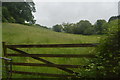
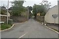
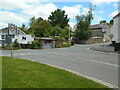
5
Aveton Gifford : Road
A road off the A379.
Image: © Lewis Clarke
Taken: 8 Jun 2021
0.10 miles
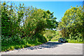
7
Junction with Fore Street
A close look at the bus shelter will reveal a picture of an Egret.
Image: © Anthony Vosper
Taken: 15 Jul 2021
0.13 miles