IMAGES TAKEN NEAR TO
Challaborough, KINGSBRIDGE, TQ7 4HT
Introduction
This page details the photographs taken nearby to TQ7 4HT by members of the Geograph project.
The Geograph project started in 2005 with the aim of publishing, organising and preserving representative images for every square kilometre of Great Britain, Ireland and the Isle of Man.

There are currently over 7.5m images from over14,400 individuals and you can help contribute to the project by visiting https://www.geograph.org.uk
Image Map
Images are licensed for reuse under creativecommons.org/licenses/by-sa/2.0
Notes
- Clicking on the map will re-center to the selected point.
- The higher the marker number, the further away the image location is from the centre of the postcode.
Image Listing (72 Images Found)
Images are licensed for reuse under creativecommons.org/licenses/by-sa/2.0
Image
Details
Distance
7
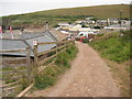
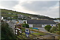
Coast path at Challaborough Bay
The South West Coast Path passing Challaborough Bay Holiday Park.
Image: © Philip Halling
Taken: 5 Jun 2011
0.09 miles
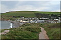
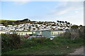
9
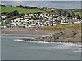
Towards Challaborough
Village of holiday chalets. View from Burgh Island
Image: © Martin Bodman
Taken: 18 Sep 2015
0.09 miles
10
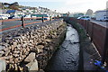
Stream, Challaborough
Looking upstream just before it flows onto the beach.
Image: © jeff collins
Taken: 9 Apr 2014
0.09 miles