IMAGES TAKEN NEAR TO
Kingston, KINGSBRIDGE, TQ7 4EZ
Introduction
This page details the photographs taken nearby to TQ7 4EZ by members of the Geograph project.
The Geograph project started in 2005 with the aim of publishing, organising and preserving representative images for every square kilometre of Great Britain, Ireland and the Isle of Man.

There are currently over 7.5m images from over14,400 individuals and you can help contribute to the project by visiting https://www.geograph.org.uk
Image Map
Images are licensed for reuse under creativecommons.org/licenses/by-sa/2.0
Notes
- Clicking on the map will re-center to the selected point.
- The higher the marker number, the further away the image location is from the centre of the postcode.
Image Listing (5 Images Found)
Images are licensed for reuse under creativecommons.org/licenses/by-sa/2.0
Image
Details
Distance
1
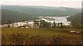
Erme estuary, 1996
A view from Holbeton Bridleway 2 of the estuary being joined by the Ayleston Brook.
Image: © Derek Harper
Taken: 3 Mar 1996
0.16 miles
2
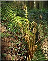
Fern in Tor Wood
A male fern (Dryopteris affinis) unfurls its fronds by the public access track above Saltercrease.
Image: © Derek Harper
Taken: 17 Apr 2011
0.21 miles
3
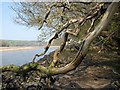
Dead wood by the Erme
The bleached and weedy limbs of a dead tree sprawling over the narrow foreshore below Tor Wood.
Image: © Derek Harper
Taken: 17 Apr 2011
0.21 miles
4
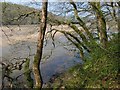
Erme estuary
The Erme estuary (looking upstream) seen through trees from Tor Wood.
Image: © Derek Harper
Taken: 17 Apr 2011
0.21 miles
5
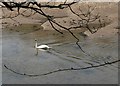
Swan on the Erme
A swan glides down the Erme estuary at low tide.
Image: © Derek Harper
Taken: 17 Apr 2011
0.21 miles