IMAGES TAKEN NEAR TO
Hingston Rise, KINGSBRIDGE, TQ7 4EW
Introduction
This page details the photographs taken nearby to Hingston Rise, TQ7 4EW by members of the Geograph project.
The Geograph project started in 2005 with the aim of publishing, organising and preserving representative images for every square kilometre of Great Britain, Ireland and the Isle of Man.

There are currently over 7.5m images from over14,400 individuals and you can help contribute to the project by visiting https://www.geograph.org.uk
Image Map
Images are licensed for reuse under creativecommons.org/licenses/by-sa/2.0
Notes
- Clicking on the map will re-center to the selected point.
- The higher the marker number, the further away the image location is from the centre of the postcode.
Image Listing (31 Images Found)
Images are licensed for reuse under creativecommons.org/licenses/by-sa/2.0
Image
Details
Distance
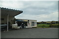
4
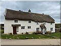
The Royal Oak Inn, Bigbury
The only pub in the village of Bigbury, mainly a restaurant. http://www.devon-explorer.co.uk/pub/Bigbury/Royal_Oak.html
Image: © Mark Land
Taken: 16 Feb 2009
0.05 miles
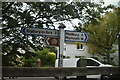
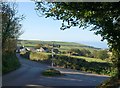
9
Joining the B3392, and a view of the sea
Image: © Rob Purvis
Taken: 22 Aug 2022
0.07 miles
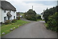
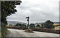
10
Pond Green Cross
The lane from Bowls Cross joins the B3392 just north of the main part of the village of Bigbury (signed to the left). Down the valley to the right is the coast at Challaborough.
Image: © Derek Harper
Taken: 24 Sep 2009
0.07 miles