IMAGES TAKEN NEAR TO
Loddiswell, KINGSBRIDGE, TQ7 4DZ
Introduction
This page details the photographs taken nearby to TQ7 4DZ by members of the Geograph project.
The Geograph project started in 2005 with the aim of publishing, organising and preserving representative images for every square kilometre of Great Britain, Ireland and the Isle of Man.

There are currently over 7.5m images from over14,400 individuals and you can help contribute to the project by visiting https://www.geograph.org.uk
Image Map
Images are licensed for reuse under creativecommons.org/licenses/by-sa/2.0
Notes
- Clicking on the map will re-center to the selected point.
- The higher the marker number, the further away the image location is from the centre of the postcode.
Image Listing (4 Images Found)
Images are licensed for reuse under creativecommons.org/licenses/by-sa/2.0
Image
Details
Distance
1
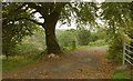
Entrance to Hazelwood
I went to an excellent concert here about 30 years ago. Now rather unfriendly notices abound, warning you to keep out. It seems to be a hotel. There is a glimpse here of the Avon valley.
Image: © Derek Harper
Taken: 2 Oct 2018
0.11 miles
2
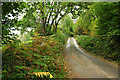
Lane near Hazelwood
From where Image was taken, looking right, up the hill towards Blackdown Rings.
Image: © Derek Harper
Taken: 2 Oct 2018
0.14 miles
3
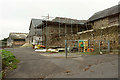
Lower Hazelwood
On the other side of the lane from Image
Image: © Derek Harper
Taken: 2 Oct 2018
0.17 miles
4
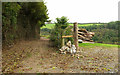
Track, Lower Hazelwood
The start of a (private) track to Hazelwood Quarry.
Image: © Derek Harper
Taken: 2 Oct 2018
0.19 miles