IMAGES TAKEN NEAR TO
Bigbury On Sea, KINGSBRIDGE, TQ7 4BA
Introduction
This page details the photographs taken nearby to TQ7 4BA by members of the Geograph project.
The Geograph project started in 2005 with the aim of publishing, organising and preserving representative images for every square kilometre of Great Britain, Ireland and the Isle of Man.

There are currently over 7.5m images from over14,400 individuals and you can help contribute to the project by visiting https://www.geograph.org.uk
Image Map
Images are licensed for reuse under creativecommons.org/licenses/by-sa/2.0
Notes
- Clicking on the map will re-center to the selected point.
- The higher the marker number, the further away the image location is from the centre of the postcode.
Image Listing (57 Images Found)
Images are licensed for reuse under creativecommons.org/licenses/by-sa/2.0
Image
Details
Distance
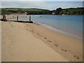
1
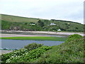
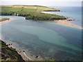
Across the Avon Estuary from Ham's End
Image: © Anthony Parkes
Taken: 28 May 2011
0.03 miles
2
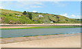
View to Cockleridge
The house overlooks the Avon and is seen here from the Bantham side at low tide.
Image: © Jonathan Billinger
Taken: 16 Jun 2011
0.04 miles
3
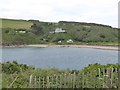
Cockleridge Point on north bank of River Avon
Image: © David Smith
Taken: 1 Jul 2016
0.04 miles
4
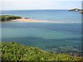
Mouth of the Avon estuary
Mouth of the Avon estuary with Hams End on the left and Burgh Island in the distance on the right.
Image: © Philip Halling
Taken: 6 Jun 2011
0.07 miles
5
River Avon estuary
The River Avon estuary viewed from Cockleridge with Bantham in the background.
Image: © Philip Halling
Taken: 6 Jun 2011
0.09 miles
6
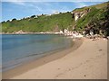
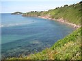
Sandy beach on the Avon estuary
A sandy beach on the Avon estuary near Bigbury-on-Sea.
Image: © Philip Halling
Taken: 6 Jun 2011
0.09 miles
7
The Avon estuary
The Avon estuary with Burgh Island and Bigbury-on-Sea in the background.
Image: © Philip Halling
Taken: 6 Jun 2011
0.10 miles
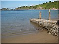
8
The Avon estuary and Burgh Island
The Avon estuary and Burgh Island viewed from the South West Coast Path.
Image: © Philip Halling
Taken: 6 Jun 2011
0.10 miles
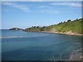
9
View across the estuary to Hams End
View across the estuary of the River Avon to Hams End, from the South West Coast Path.
Image: © Philip Halling
Taken: 6 Jun 2011
0.11 miles
10
Mouth of the Avon estuary
View of the north side of the mouth of the Avon estuary with Bigbury-on-Sea and Burgh Island in the background. Burgh Island Hotel can be seen on the island.
Image: © Philip Halling
Taken: 6 Jun 2011
0.11 miles