IMAGES TAKEN NEAR TO
KINGSBRIDGE, TQ7 4AE
Introduction
This page details the photographs taken nearby to TQ7 4AE by members of the Geograph project.
The Geograph project started in 2005 with the aim of publishing, organising and preserving representative images for every square kilometre of Great Britain, Ireland and the Isle of Man.

There are currently over 7.5m images from over14,400 individuals and you can help contribute to the project by visiting https://www.geograph.org.uk
Image Map (Loading...)


Getting Data...Please wait
Leaflet Map data © OpenStreetMap
Images are licensed for reuse under creativecommons.org/licenses/by-sa/2.0
Notes
- Clicking on the map will re-center to the selected point.
- The higher the marker number, the further away the image location is from the centre of the postcode.
Image Listing (5 Images Found)
Images are licensed for reuse under creativecommons.org/licenses/by-sa/2.0
Image
Details
Distance
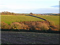
4
Zig-zag hedges
Looking north-east from the lane between West Alvington and Sorley.
Image: © Jonathan Billinger
Taken: 10 Dec 2008
0.17 miles
5
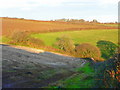
Looking east towards Norton
The farm buildings can just be seen over the hill.
In the distence, right, is housing on the northern edge of Kingsbridge.
Mixed arable and pasture.
Image: © Jonathan Billinger
Taken: 10 Dec 2008
0.22 miles