IMAGES TAKEN NEAR TO
South Milton, KINGSBRIDGE, TQ7 3JX
Introduction
This page details the photographs taken nearby to TQ7 3JX by members of the Geograph project.
The Geograph project started in 2005 with the aim of publishing, organising and preserving representative images for every square kilometre of Great Britain, Ireland and the Isle of Man.

There are currently over 7.5m images from over14,400 individuals and you can help contribute to the project by visiting https://www.geograph.org.uk
Image Map (Loading...)


Getting Data...Please wait
Leaflet Map data © OpenStreetMap
Images are licensed for reuse under creativecommons.org/licenses/by-sa/2.0
Notes
- Clicking on the map will re-center to the selected point.
- The higher the marker number, the further away the image location is from the centre of the postcode.
Image Listing (13 Images Found)
Images are licensed for reuse under creativecommons.org/licenses/by-sa/2.0
Image
Details
Distance
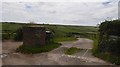
1
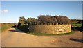
Wall, Crossparks
A rather appealing curved wall by the lane between South Milton Sands and South Milton. Image], Image] and Image] were also taken here, looking off to the right.
Image: © Derek Harper
Taken: 5 Dec 2014
0.03 miles
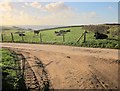
2
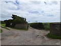
Track to South Milton at Crossparks
An old route along the ridge; the surfaced road follows the valley to the north
Image: © David Smith
Taken: 1 Jul 2016
0.03 miles
3
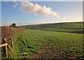
Towards South Huish
From the same spot as Image On the other side of the field boundary is a route with public access along a green lane that runs up the ridgetop to Sutton.
Image: © Derek Harper
Taken: 5 Dec 2014
0.04 miles
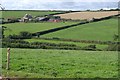
4
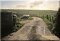
Track to Southdown Farm
Across a cattle grid from the lane between South Milton and South Milton Sands.
Image: © Derek Harper
Taken: 5 Dec 2014
0.04 miles
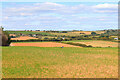
6
Cattle, Southdown Farm
Looking across the track shown in Image, with the sea in the distance and buildings at Thurlestone Sands.
Image: © Derek Harper
Taken: 5 Dec 2014
0.04 miles
7
View from Horsewell Lane
Looking towards South Milton.
Image: © Wayland Smith
Taken: 18 Sep 2022
0.07 miles
9
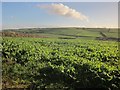
Crop, Southdown Farm
Some sort of brassica, seen from the lane to South Milton Sands. The valley also leads down to the sea at the Sands.
Image: © Derek Harper
Taken: 5 Dec 2014
0.17 miles
10
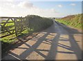
Lane to South Milton Sands
Passing the gateway from which Image was taken. A glimpse of the sea ahead.
Image: © Derek Harper
Taken: 5 Dec 2014
0.18 miles