IMAGES TAKEN NEAR TO
South Huish, KINGSBRIDGE, TQ7 3EF
Introduction
This page details the photographs taken nearby to TQ7 3EF by members of the Geograph project.
The Geograph project started in 2005 with the aim of publishing, organising and preserving representative images for every square kilometre of Great Britain, Ireland and the Isle of Man.

There are currently over 7.5m images from over14,400 individuals and you can help contribute to the project by visiting https://www.geograph.org.uk
Image Map
Images are licensed for reuse under creativecommons.org/licenses/by-sa/2.0
Notes
- Clicking on the map will re-center to the selected point.
- The higher the marker number, the further away the image location is from the centre of the postcode.
Image Listing (4 Images Found)
Images are licensed for reuse under creativecommons.org/licenses/by-sa/2.0
Image
Details
Distance
1
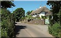
Thatched cottage, Rugwell
On Burleigh Lane, climbing towards Galmpton Cross.
Image: © Derek Harper
Taken: 8 Jun 2016
0.05 miles
2
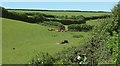
Cattle at Rugwell
Image: © Derek Harper
Taken: 8 Jun 2016
0.09 miles
3
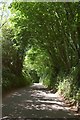
Burleigh Lane
The trees only clothe the roadside; on either side are pasture fields.
Image: © Derek Harper
Taken: 8 Jun 2016
0.23 miles
4
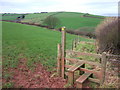
Approaching Burleigh
The valley ahead, which drains to the right and then turns to meet the sea (visible extreme right) at Thurlestone, carries the lane to Hope Cove. South Huish Footpath 1 crosses a stile to descend a field to meet it.
Image: © Derek Harper
Taken: 27 Jan 2007
0.23 miles