IMAGES TAKEN NEAR TO
Malborough, KINGSBRIDGE, TQ7 3DU
Introduction
This page details the photographs taken nearby to TQ7 3DU by members of the Geograph project.
The Geograph project started in 2005 with the aim of publishing, organising and preserving representative images for every square kilometre of Great Britain, Ireland and the Isle of Man.

There are currently over 7.5m images from over14,400 individuals and you can help contribute to the project by visiting https://www.geograph.org.uk
Image Map
Images are licensed for reuse under creativecommons.org/licenses/by-sa/2.0
Notes
- Clicking on the map will re-center to the selected point.
- The higher the marker number, the further away the image location is from the centre of the postcode.
Image Listing (6 Images Found)
Images are licensed for reuse under creativecommons.org/licenses/by-sa/2.0
Image
Details
Distance
1
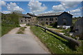
Approaching Southdown Farm
It appears as if most of the farm buildings have been turned into self catering accommodation by the National Trust who own the farm.
Image: © jeff collins
Taken: 14 May 2014
0.03 miles
2
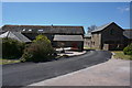
Part of Southdown Farm
Owned by the National Trust and divided in to self catering apartments.
Image: © jeff collins
Taken: 14 May 2014
0.04 miles
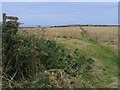
3
Footpath to Rew
Just after leaving Southdown Farm.
Image: © jeff collins
Taken: 14 May 2014
0.08 miles
4
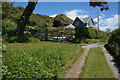
Isolated house
By the track to Southdown Farm.
Image: © jeff collins
Taken: 14 May 2014
0.11 miles
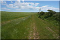
5
Footpath to Southdown Farm
Footpath cuts through the crops to Southdown Farm
Image: © Shaun Ferguson
Taken: 31 Jul 2009
0.13 miles
6
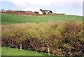
Hillside near Soar Mill Cove, Malborough
In the foreground is a thicket of thorn trees alongside the stream, and above it pasture land. Then Hamstone Cottage, one of a few holiday cottages on the lane (footpath further down) to the Cove.
Image: © Humphrey Bolton
Taken: 12 Apr 1991
0.18 miles