IMAGES TAKEN NEAR TO
Malborough, KINGSBRIDGE, TQ7 3DT
Introduction
This page details the photographs taken nearby to TQ7 3DT by members of the Geograph project.
The Geograph project started in 2005 with the aim of publishing, organising and preserving representative images for every square kilometre of Great Britain, Ireland and the Isle of Man.

There are currently over 7.5m images from over14,400 individuals and you can help contribute to the project by visiting https://www.geograph.org.uk
Image Map (Loading...)


Getting Data...Please wait
Leaflet Map data © OpenStreetMap
Images are licensed for reuse under creativecommons.org/licenses/by-sa/2.0
Notes
- Clicking on the map will re-center to the selected point.
- The higher the marker number, the further away the image location is from the centre of the postcode.
Image Listing (19 Images Found)
Images are licensed for reuse under creativecommons.org/licenses/by-sa/2.0
Image
Details
Distance
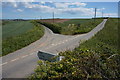
2
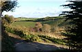
Drive to Furzedown Farm
The drive down to the farm swings sgarply right here, while Malborough Footpath 10, which has followed it from the ridge road, turns left, across to meet the Combe valley higher up.
Image: © Derek Harper
Taken: 25 Nov 2010
0.02 miles
3
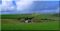
Furzedown Farm
The farm, tucked into a side valley above the South Sands valley, seem almost in danger of being coveerd by the netting used on the fields around it. See also Image, which looks across the side valley from the other side.
Image: © Derek Harper
Taken: 1 Oct 2009
0.02 miles
4
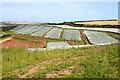
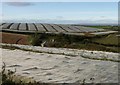
Crops Under Netting
From a distance this looks very much like the polythene sheets which are often used to help the growth of maize but this appears to be fine netting under which some type of brassicas are being grown.
Image: © Tony Atkin
Taken: 30 Jul 2009
0.06 miles
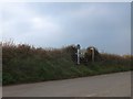
5
All rolled up
Straw bales in the fields next to Furzedown Farm. Taken from where the footpath joins the road at Rew Cross.
Image: © Anthony Vosper
Taken: 15 Sep 2012
0.09 miles
6
Rew Cross
Straw bales catch the late afternoon's sun.
Image: © Anthony Vosper
Taken: 15 Sep 2012
0.09 miles
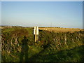
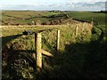
7
Rew Cross
The steps are the start of a footpath to Southdown Farm across National Trust land
Image: © David Smith
Taken: 20 Feb 2013
0.10 miles
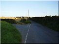
8
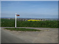
Minor road junction
Left to Rew and Combe right to Higher and Lower Soar.
Image: © jeff collins
Taken: 14 May 2014
0.10 miles
9
Field boundary, Furzedown Farm
A new bank and fence running along the contour above the farm makes life slightly confusing for the mapreader.
Image: © Derek Harper
Taken: 25 Nov 2010
0.10 miles