IMAGES TAKEN NEAR TO
Church Wells, KINGSBRIDGE, TQ7 2QR
Introduction
This page details the photographs taken nearby to Church Wells, TQ7 2QR by members of the Geograph project.
The Geograph project started in 2005 with the aim of publishing, organising and preserving representative images for every square kilometre of Great Britain, Ireland and the Isle of Man.

There are currently over 7.5m images from over14,400 individuals and you can help contribute to the project by visiting https://www.geograph.org.uk
Image Map
Images are licensed for reuse under creativecommons.org/licenses/by-sa/2.0
Notes
- Clicking on the map will re-center to the selected point.
- The higher the marker number, the further away the image location is from the centre of the postcode.
Image Listing (290 Images Found)
Images are licensed for reuse under creativecommons.org/licenses/by-sa/2.0
Image
Details
Distance
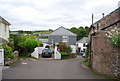
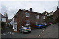
2
Church Lane, Slapton
Image: © Derek Harper
Taken: 16 Jun 2009
0.01 miles
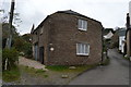
5
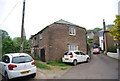
Former cartshed
Grade II listed. http://www.britishlistedbuildings.co.uk/en-99886-outbuilding-adjoining-south-west-of-churc
Image: © N Chadwick
Taken: 2 Jun 2012
0.01 miles
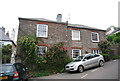
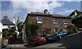
7
Edenhurst
Grade II listed. http://www.britishlistedbuildings.co.uk/101163994-edenhurst-and-sunny-side-slapton
Image: © N Chadwick
Taken: 23 Oct 2016
0.01 miles
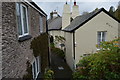

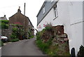
10
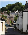
Slapton
The village street climbs in the direction of the church.
Image: © Derek Harper
Taken: 16 Jun 2009
0.01 miles