IMAGES TAKEN NEAR TO
Tanpits Lane, KINGSBRIDGE, TQ7 2LG
Introduction
This page details the photographs taken nearby to Tanpits Lane, TQ7 2LG by members of the Geograph project.
The Geograph project started in 2005 with the aim of publishing, organising and preserving representative images for every square kilometre of Great Britain, Ireland and the Isle of Man.

There are currently over 7.5m images from over14,400 individuals and you can help contribute to the project by visiting https://www.geograph.org.uk
Image Map (Loading...)


Getting Data...Please wait
Leaflet Map data © OpenStreetMap
Images are licensed for reuse under creativecommons.org/licenses/by-sa/2.0
Notes
- Clicking on the map will re-center to the selected point.
- The higher the marker number, the further away the image location is from the centre of the postcode.
Image Listing (60 Images Found)
Images are licensed for reuse under creativecommons.org/licenses/by-sa/2.0
Image
Details
Distance
3
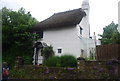
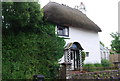
Shorneywell Cottage
Grade II listed. http://www.britishlistedbuildings.co.uk/en-99981-shorneywell-stokenham-devon
Image: © N Chadwick
Taken: 7 Jun 2012
0.04 miles
5
Thatched cottage, Chillington
A Grade II listed building. http://www.britishlistedbuildings.co.uk/en-99982-thatch-cottage-including-front-garden-are
Image: © N Chadwick
Taken: 30 May 2008
0.05 miles
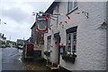
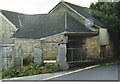
7
The Bear and Blacksmith pub in Chillington
Image: © Rod Allday
Taken: 18 Sep 2022
0.06 miles
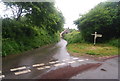
10
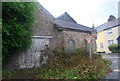
Old Forge, Chillington
This uninspiring building stands at the junction of the main street (the A379) and Tanpits Lane. It was a working blacksmith's forge for many years, perhaps centuries. The tanpits referred to in the name of the lane lay further to the south, on the shore of in Frogmore Creek which was open to the sea. They were used for treading the animal hides in the salt water as the beginning of the tanning process.
Image: © Carol Walker
Taken: 27 Feb 2007
0.07 miles