IMAGES TAKEN NEAR TO
Beeson, KINGSBRIDGE, TQ7 2HW
Introduction
This page details the photographs taken nearby to TQ7 2HW by members of the Geograph project.
The Geograph project started in 2005 with the aim of publishing, organising and preserving representative images for every square kilometre of Great Britain, Ireland and the Isle of Man.

There are currently over 7.5m images from over14,400 individuals and you can help contribute to the project by visiting https://www.geograph.org.uk
Image Map
Images are licensed for reuse under creativecommons.org/licenses/by-sa/2.0
Notes
- Clicking on the map will re-center to the selected point.
- The higher the marker number, the further away the image location is from the centre of the postcode.
Image Listing (2 Images Found)
Images are licensed for reuse under creativecommons.org/licenses/by-sa/2.0
Image
Details
Distance
1
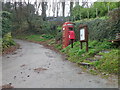
Village communications, Beeson
A postbox, the village notice board and a K6 telephone box stand together at a junction of small village roads.
In 1935, the Post Office commissioned a new kiosk from Sir Giles Gilbert Scott to celebrate the Jubilee of King George V. The K6 Jubilee Kiosk, as it is known, was similar to the K2 box, being made of cast iron and painted red but was 25% lighter in weight. By the end of the 1930s there were 20,000 K6 telephone boxes in use all over the UK.
Image: © Maigheach-gheal
Taken: 14 Feb 2011
0.05 miles
2
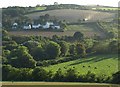
Widdicombe
Another view from Stokenham Footpath 17 across Image, higher up the valley. A flock of rooks, or crows, takes flight in the foreground. The houses are at the western edge of the village of Beeson, in Image
Image: © Derek Harper
Taken: 10 Sep 2009
0.19 miles