IMAGES TAKEN NEAR TO
Helmers Way, KINGSBRIDGE, TQ7 2FA
Introduction
This page details the photographs taken nearby to Helmers Way, TQ7 2FA by members of the Geograph project.
The Geograph project started in 2005 with the aim of publishing, organising and preserving representative images for every square kilometre of Great Britain, Ireland and the Isle of Man.

There are currently over 7.5m images from over14,400 individuals and you can help contribute to the project by visiting https://www.geograph.org.uk
Image Map
Images are licensed for reuse under creativecommons.org/licenses/by-sa/2.0
Notes
- Clicking on the map will re-center to the selected point.
- The higher the marker number, the further away the image location is from the centre of the postcode.
Image Listing (59 Images Found)
Images are licensed for reuse under creativecommons.org/licenses/by-sa/2.0
Image
Details
Distance
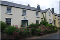
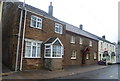
1
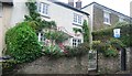
Helmers Meadow
A village centre development.
Image: © N Chadwick
Taken: 7 Jun 2012
0.00 miles
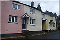
4
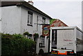
Beer delivery at The Open Arms, Chillington
Image: © N Chadwick
Taken: 30 May 2008
0.02 miles
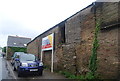
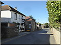
6
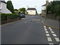
A379 Chillington
By Coleridge Lane the A379 passing by the Post Office in Chillington
Image: © Shaun Ferguson
Taken: 31 Jul 2009
0.03 miles
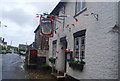
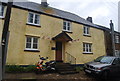
8
The Bear and Blacksmith pub in Chillington
Image: © Rod Allday
Taken: 18 Sep 2022
0.03 miles