IMAGES TAKEN NEAR TO
Sherford, KINGSBRIDGE, TQ7 2BJ
Introduction
This page details the photographs taken nearby to TQ7 2BJ by members of the Geograph project.
The Geograph project started in 2005 with the aim of publishing, organising and preserving representative images for every square kilometre of Great Britain, Ireland and the Isle of Man.

There are currently over 7.5m images from over14,400 individuals and you can help contribute to the project by visiting https://www.geograph.org.uk
Image Map (Loading...)


Getting Data...Please wait
Leaflet Map data © OpenStreetMap
Images are licensed for reuse under creativecommons.org/licenses/by-sa/2.0
Notes
- Clicking on the map will re-center to the selected point.
- The higher the marker number, the further away the image location is from the centre of the postcode.
Image Listing (6 Images Found)
Images are licensed for reuse under creativecommons.org/licenses/by-sa/2.0
Image
Details
Distance
1
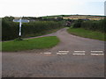
Bowden Cross
Bowden Cross looking to Higher Bowden
Image: © Shaun Ferguson
Taken: 30 Jul 2009
0.03 miles
2
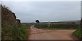
Bowden Cross
Three roads meet here, the fourth arm of the crossroads is a farm track
Image: © David Smith
Taken: 20 Feb 2013
0.07 miles
3
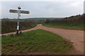
Bowden Cross and the road to Bowden
The fingers on the sign do not give distances
Image: © David Smith
Taken: 20 Feb 2013
0.07 miles
4
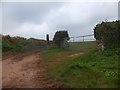
Farm track and field gate at Bowden Cross
This is the fourth arm of the crossroads at Bowden Cross
Image: © David Smith
Taken: 20 Feb 2013
0.10 miles
5
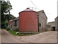
Bowden
The farmhouse for these buildings now seems to be a new building at Higher Bowden, 300 metres away.
Image: © Derek Harper
Taken: 25 Aug 2006
0.18 miles
6
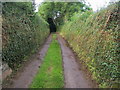
Lane heading to Bowden
Single track lane heading to Bowden
Image: © Shaun Ferguson
Taken: 30 Jul 2009
0.23 miles