IMAGES TAKEN NEAR TO
Sherford, KINGSBRIDGE, TQ7 2BG
Introduction
This page details the photographs taken nearby to TQ7 2BG by members of the Geograph project.
The Geograph project started in 2005 with the aim of publishing, organising and preserving representative images for every square kilometre of Great Britain, Ireland and the Isle of Man.

There are currently over 7.5m images from over14,400 individuals and you can help contribute to the project by visiting https://www.geograph.org.uk
Image Map
Images are licensed for reuse under creativecommons.org/licenses/by-sa/2.0
Notes
- Clicking on the map will re-center to the selected point.
- The higher the marker number, the further away the image location is from the centre of the postcode.
Image Listing (6 Images Found)
Images are licensed for reuse under creativecommons.org/licenses/by-sa/2.0
Image
Details
Distance
1
Grass field near Harleston
Image: © Derek Harper
Taken: 11 Apr 2019
0.08 miles
2
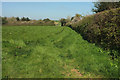
Grass field near Harleston
From the lane northwest of Harleston. The wood on the left is by Valley Springs.
Image: © Derek Harper
Taken: 11 Apr 2019
0.14 miles
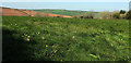
3
Grass field near Harleston
Looking left from where Image] was taken, with a little overlap. The further fields are across the Start Stream valley.
Image: © Derek Harper
Taken: 11 Apr 2019
0.19 miles
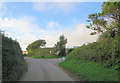
4
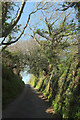
Lane near Harleston
Climbing between banks from the hamlet towards Valley Springs.
Image: © Derek Harper
Taken: 11 Apr 2019
0.23 miles
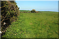
5
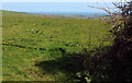
Grass field near Harleston
Looking right from where Image] was taken. The view extends down the Start Stream valley to the sea at Slapton Sands.
Image: © Derek Harper
Taken: 11 Apr 2019
0.24 miles