IMAGES TAKEN NEAR TO
Ilton Way, KINGSBRIDGE, TQ7 1DT
Introduction
This page details the photographs taken nearby to Ilton Way, TQ7 1DT by members of the Geograph project.
The Geograph project started in 2005 with the aim of publishing, organising and preserving representative images for every square kilometre of Great Britain, Ireland and the Isle of Man.

There are currently over 7.5m images from over14,400 individuals and you can help contribute to the project by visiting https://www.geograph.org.uk
Image Map
Images are licensed for reuse under creativecommons.org/licenses/by-sa/2.0
Notes
- Clicking on the map will re-center to the selected point.
- The higher the marker number, the further away the image location is from the centre of the postcode.
Image Listing (34 Images Found)
Images are licensed for reuse under creativecommons.org/licenses/by-sa/2.0
Image
Details
Distance
1
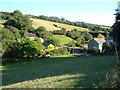
Washbrook
Washabrook (sic) Mill and Washbrook Farm on either side of the stream down the Washbrook valley.
Image: © Derek Harper
Taken: 24 Aug 2006
0.07 miles
2
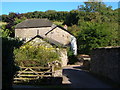
Washabrook Mill
Former watermill in a valley just east of Kingsbridge.
Image: © Derek Harper
Taken: 24 Aug 2006
0.10 miles
3
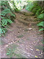
Byway from Washabrook Mill to Shindle Mill
An old route but newly-declared a public byway, this steep track just above Washabrook Mill exposes a rock base.
Image: © Derek Harper
Taken: 24 Aug 2006
0.11 miles
4
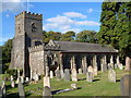
St Thomas a Becket church, Dodbrooke
Dodbrooke is now an eastern part of Kingsbridge, but this medieval church was the core of a distinct community. There was a spire which fell in 1785.
Image: © Derek Harper
Taken: 24 Aug 2006
0.12 miles
5
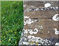
Ordnance Survey Cut Mark
This OS cut mark can be found on the west face of St Thomas Becket's Church. It marks a point 37.637m above mean sea level.
Image: © Adrian Dust
Taken: 26 Mar 2019
0.13 miles
6
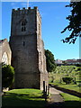
St Thomas a Becket church, Dodbrooke
The tower from the north, with the churchyard behind, and housing on Kenwith Drive up the hill beyond.
Image: © Derek Harper
Taken: 24 Aug 2006
0.13 miles
7
![Parish church [2]](https://s0.geograph.org.uk/geophotos/07/57/60/7576060_3e7644dc_120x120.jpg)
Parish church [2]
The Anglican parish church of St Thomas of Canterbury was built in the 15th century, replacing an earlier church on the site. The church was restored in 1780 and again in 1887. Constructed of rubble stone with ashlar dressings under slate roofs. There is a 12th century font. Listed, grade I, with details at: https://historicengland.org.uk/listing/the-list/list-entry/1317351
Kingsbridge is a market town in the South Hams district of Devon. It is located at the head of an estuary some 17 miles southwest of Torquay and about 17 miles southeast of Plymouth. The town formed around a bridge built in or before the 10th century between two royal estates, giving it the name of Kyngysbrygge ("King's bridge"). Situated in the South Devon Area of Outstanding Natural Beauty and close to the South Devon coast, the town is a popular tourist destination.
Image: © Michael Dibb
Taken: 27 Jun 2023
0.13 miles
8
![Kingsbridge houses [15]](https://s0.geograph.org.uk/geophotos/07/57/61/7576100_ebce6dc8_120x120.jpg)
Kingsbridge houses [15]
Church House, number 148 Church Street, was built in the 18th century with later alterations. Constructed of rubble stone, partly hung slate to the upper floor, under a hipped slate roof. Listed, grade II, with details at: https://historicengland.org.uk/listing/the-list/list-entry/1107511
Kingsbridge is a market town in the South Hams district of Devon. It is located at the head of an estuary some 17 miles southwest of Torquay and about 17 miles southeast of Plymouth. The town formed around a bridge built in or before the 10th century between two royal estates, giving it the name of Kyngysbrygge ("King's bridge"). Situated in the South Devon Area of Outstanding Natural Beauty and close to the South Devon coast, the town is a popular tourist destination.
Image: © Michael Dibb
Taken: 27 Jun 2023
0.15 miles
9
![Parish church [3]](https://s3.geograph.org.uk/geophotos/07/57/60/7576063_feb306c1_120x120.jpg)
Parish church [3]
Part of the churchyard.
The Anglican parish church of St Thomas of Canterbury was built in the 15th century, replacing an earlier church on the site. The church was restored in 1780 and again in 1887. Constructed of rubble stone with ashlar dressings under slate roofs. There is a 12th century font. Listed, grade I, with details at: https://historicengland.org.uk/listing/the-list/list-entry/1317351
Kingsbridge is a market town in the South Hams district of Devon. It is located at the head of an estuary some 17 miles southwest of Torquay and about 17 miles southeast of Plymouth. The town formed around a bridge built in or before the 10th century between two royal estates, giving it the name of Kyngysbrygge ("King's bridge"). Situated in the South Devon Area of Outstanding Natural Beauty and close to the South Devon coast, the town is a popular tourist destination.
Image: © Michael Dibb
Taken: 27 Jun 2023
0.15 miles
10
![Parish church [4]](https://s0.geograph.org.uk/geophotos/07/57/60/7576064_6bd6ac7f_120x120.jpg)
Parish church [4]
Part of the churchyard.
The Anglican parish church of St Thomas of Canterbury was built in the 15th century, replacing an earlier church on the site. The church was restored in 1780 and again in 1887. Constructed of rubble stone with ashlar dressings under slate roofs. There is a 12th century font. Listed, grade I, with details at: https://historicengland.org.uk/listing/the-list/list-entry/1317351
Kingsbridge is a market town in the South Hams district of Devon. It is located at the head of an estuary some 17 miles southwest of Torquay and about 17 miles southeast of Plymouth. The town formed around a bridge built in or before the 10th century between two royal estates, giving it the name of Kyngysbrygge ("King's bridge"). Situated in the South Devon Area of Outstanding Natural Beauty and close to the South Devon coast, the town is a popular tourist destination.
Image: © Michael Dibb
Taken: 27 Jun 2023
0.15 miles