IMAGES TAKEN NEAR TO
Chapel Lane, DARTMOUTH, TQ6 9RJ
Introduction
This page details the photographs taken nearby to Chapel Lane, TQ6 9RJ by members of the Geograph project.
The Geograph project started in 2005 with the aim of publishing, organising and preserving representative images for every square kilometre of Great Britain, Ireland and the Isle of Man.

There are currently over 7.5m images from over14,400 individuals and you can help contribute to the project by visiting https://www.geograph.org.uk
Image Map
Images are licensed for reuse under creativecommons.org/licenses/by-sa/2.0
Notes
- Clicking on the map will re-center to the selected point.
- The higher the marker number, the further away the image location is from the centre of the postcode.
Image Listing (1045 Images Found)
Images are licensed for reuse under creativecommons.org/licenses/by-sa/2.0
Image
Details
Distance
1
Catholic church for sale
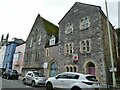
The former church of St John the Baptist, Newcomen Road, Dartmouth (left of the common entrance) and the presbytery (right) were apparently still open in 2014 Image but now closed and for sale. Both were built in 1868-69 by architect J A Hansom, the church later extended (to the rear, presumably). The buildings are grade II listed under two entries (church 1209842, presbytery 1297097).
Image: © Stephen Craven
Taken: 12 Jul 2021
0.02 miles
2
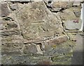
Ordnance Survey Cut Mark
This OS cut mark can be found on the wall of No41 Above Town. It marks a point 31.550m above mean sea level.
Image: © Adrian Dust
Taken: 28 Mar 2019
0.02 miles
3

Newcomen Road, Dartmouth, Devon
Taken at its junction with Higher Street
Image: © Derek Voller
Taken: 16 Sep 2013
0.02 miles

5
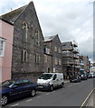
Catholic Church of St John the Baptist, Dartmouth
Viewed across Newcomen Road. The church is in the Catholic
Diocese of Plymouth which serves Devon, Dorset and Cornwall.
Image: © Jaggery
Taken: 5 Jul 2014
0.02 miles
6
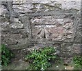
Ordnance Survey Cut Mark
This OS cut mark can be found on the Roman Catholic Church. It marks a point 10.080m above mean sea level.
Image: © Adrian Dust
Taken: 28 Mar 2019
0.03 miles
8
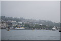
Dartmouth.
View taken from downstream, near Dartmouth Castle.
Image: © Andy Peacock
Taken: 6 Aug 2002
0.03 miles
9
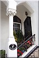
Entrance to The Old Manse, Dartmouth.
One of the many well-to-do townhouses in Dartmouth.
Image: © Jonathan Billinger
Taken: 8 Sep 2005
0.03 miles
10

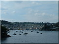
Dartmouth from Southtown
Looking up the water frontage of the town, with a vehicle ferry leaving the slipway on Lower Street, the Britannia Royal Naval College above, and houses on Ridge Hill between town and college.
Image: © Derek Harper
Taken: 22 Aug 2012
0.03 miles