IMAGES TAKEN NEAR TO
South Ford Road, DARTMOUTH, TQ6 9QS
Introduction
This page details the photographs taken nearby to South Ford Road, TQ6 9QS by members of the Geograph project.
The Geograph project started in 2005 with the aim of publishing, organising and preserving representative images for every square kilometre of Great Britain, Ireland and the Isle of Man.

There are currently over 7.5m images from over14,400 individuals and you can help contribute to the project by visiting https://www.geograph.org.uk
Image Map (Loading...)


Getting Data...Please wait
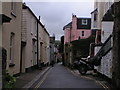
Leaflet Map data © OpenStreetMap
Images are licensed for reuse under creativecommons.org/licenses/by-sa/2.0
Notes
- Clicking on the map will re-center to the selected point.
- The higher the marker number, the further away the image location is from the centre of the postcode.
Image Listing (911 Images Found)
Images are licensed for reuse under creativecommons.org/licenses/by-sa/2.0
Image
Details
Distance
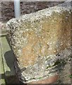
2
Ordnance Survey Cut Mark
This OS cut mark can be found on the wall of No19 South Ford Road. It marks a point 17.118m above mean sea level.
Image: © Adrian Dust
Taken: 28 Mar 2019
0.01 miles
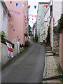
3
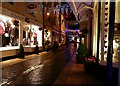
Foss Street
An evening view of the boutique style shops that line this narrow street near the market in Dartmouth.
Image: © Wendy North
Taken: 17 Dec 2008
0.01 miles
4
Lake Street, Dartmouth
West from the corner of Victoria Place.
Image: © Jaggery
Taken: 5 Jul 2014
0.02 miles
5
Vino's in Dartmouth
Pizzeria and grill in Victoria Road.
Image: © Jaggery
Taken: 5 Jul 2014
0.03 miles
6
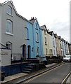
Three blind windows, Victoria Place, Dartmouth
The vertical row of three blind windows may have resulted from a measure taken by a former householder to reduce the liability under the Window Tax, introduced in 1696 in the reign of King William III, repealed in 1851.
The entrance door to The Clifton Surgery is at the left edge of the view.
Image: © Jaggery
Taken: 5 Jul 2014
0.03 miles
7
Ordnance Survey Cut Mark
This OS cut mark can be found on the wall of No47 South Ford Road. It marks a point 16.944m above mean sea level.
Image: © Adrian Dust
Taken: 28 Mar 2019
0.04 miles
8
Dartmouth: bunting on Crowther?s Hill
This higher part of Crowther's Hill, west of the junction with Above Town, is indicated by road sign as having a gradient of 1 in 3, bearing out the map symbol of two arrows meaning '1 in 5 or steeper'.
Image: © Chris Downer
Taken: 27 Aug 2009
0.04 miles
9
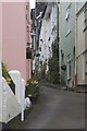
Crowther's Hill
Looking up Crowther's Hill from Above Town.
Image: © S J Dowden
Taken: 26 Apr 2015
0.04 miles
10
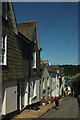
Crowther's Hill, Dartmouth
The road drops steeply into the centre of town.
Image: © Derek Harper
Taken: 4 Aug 2021
0.04 miles