IMAGES TAKEN NEAR TO
Carey Road, DARTMOUTH, TQ6 9LT
Introduction
This page details the photographs taken nearby to Carey Road, TQ6 9LT by members of the Geograph project.
The Geograph project started in 2005 with the aim of publishing, organising and preserving representative images for every square kilometre of Great Britain, Ireland and the Isle of Man.

There are currently over 7.5m images from over14,400 individuals and you can help contribute to the project by visiting https://www.geograph.org.uk
Image Map (Loading...)


Getting Data...Please wait
Leaflet Map data © OpenStreetMap
Images are licensed for reuse under creativecommons.org/licenses/by-sa/2.0
Notes
- Clicking on the map will re-center to the selected point.
- The higher the marker number, the further away the image location is from the centre of the postcode.
Image Listing (18 Images Found)
Images are licensed for reuse under creativecommons.org/licenses/by-sa/2.0
Image
Details
Distance
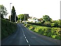
2
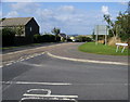
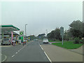
Townstal Road
Townstal Road (A3122) passing Milton Lane heading to Dartmouth
Image: © Shaun Ferguson
Taken: 13 Aug 2010
0.04 miles
4
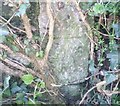
Ordnance Survey Cut Mark
This OS cut mark can be found on the cemetery wall. It marks a point 139.559m above mean sea level.
Image: © Adrian Dust
Taken: 28 Mar 2019
0.06 miles
5
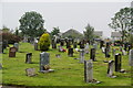
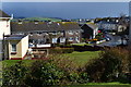
Longcross Cemetery
Situated right at the top of the hill on the edge of Dartmouth.
Image: © Bill Boaden
Taken: 25 Jun 2011
0.14 miles
7
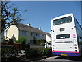
Dartmouth : Townstal Road & First Bus
The back of a bus as it stops at a bus stop with houses on the other side of the road.
Image: © Lewis Clarke
Taken: 16 Jun 2010
0.16 miles
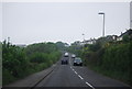
10
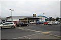
Lidl Supermarket
On the outskirts of Dartmouth, close to the A3122.
Image: © jeff collins
Taken: 2 Dec 2013
0.21 miles