IMAGES TAKEN NEAR TO
Townstal Crescent, DARTMOUTH, TQ6 9JH
Introduction
This page details the photographs taken nearby to Townstal Crescent, TQ6 9JH by members of the Geograph project.
The Geograph project started in 2005 with the aim of publishing, organising and preserving representative images for every square kilometre of Great Britain, Ireland and the Isle of Man.

There are currently over 7.5m images from over14,400 individuals and you can help contribute to the project by visiting https://www.geograph.org.uk
Image Map
Images are licensed for reuse under creativecommons.org/licenses/by-sa/2.0
Notes
- Clicking on the map will re-center to the selected point.
- The higher the marker number, the further away the image location is from the centre of the postcode.
Image Listing (58 Images Found)
Images are licensed for reuse under creativecommons.org/licenses/by-sa/2.0
Image
Details
Distance
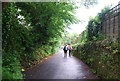
7
Archway Cottage
The steps lead down to Old Mill Lane
Image: © Geoff Gartside
Taken: 26 Oct 2008
0.05 miles
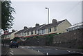
8
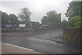
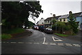
Townstal Pathfield
A no through road off Townstal Road.
Image: © N Chadwick
Taken: 6 Jun 2012
0.05 miles
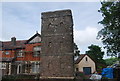
9
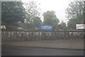
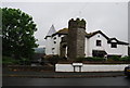
St Clement's Church
Dartmouth's parish church.
Image: © N Chadwick
Taken: 6 Jun 2012
0.06 miles