IMAGES TAKEN NEAR TO
Vicarage Hill, DARTMOUTH, TQ6 9EW
Introduction
This page details the photographs taken nearby to Vicarage Hill, TQ6 9EW by members of the Geograph project.
The Geograph project started in 2005 with the aim of publishing, organising and preserving representative images for every square kilometre of Great Britain, Ireland and the Isle of Man.

There are currently over 7.5m images from over14,400 individuals and you can help contribute to the project by visiting https://www.geograph.org.uk
Image Map (Loading...)


Getting Data...Please wait
Leaflet Map data © OpenStreetMap
Images are licensed for reuse under creativecommons.org/licenses/by-sa/2.0
Notes
- Clicking on the map will re-center to the selected point.
- The higher the marker number, the further away the image location is from the centre of the postcode.
Image Listing (586 Images Found)
Images are licensed for reuse under creativecommons.org/licenses/by-sa/2.0
Image
Details
Distance
1
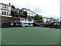
Dartmouth Bowling Club
Artificial bowling green viewed from Victoria Road.
Image: © Jaggery
Taken: 5 Jul 2014
0.03 miles
2
Ordnance Survey Cut Mark
This OS cut mark can be found on the wall north side of Fairview. It marks a point 41.282m above mean sea level.
Image: © Adrian Dust
Taken: 28 Mar 2019
0.04 miles
3
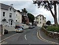
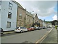
Vicarage Hill, Dartmouth
Viewed from the Victoria Road end. The road forks at the house ahead.
A narrower Vicarage Hill continues on the left side. Northford Road is on the right side of the house.
Image: © Jaggery
Taken: 5 Jul 2014
0.04 miles
4
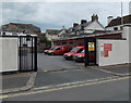
Dartmouth Delivery Office yard
Viewed across Albert Place.
Image: © Jaggery
Taken: 5 Jul 2014
0.05 miles
5
Dartmouth Guildhall
On Victoria Road; dated 1849, now municipal offices. Listed by Historic England (Grade II): http://www.imagesofengland.org.uk/Details/Default.aspx?id=387398&mode=adv
Image: © Mike Faherty
Taken: 1 Apr 2017
0.05 miles
6
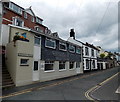
Roseville Street, Dartmouth
Viewed from the corner of Albert Place.
Image: © Jaggery
Taken: 5 Jul 2014
0.06 miles
7
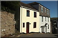
Top of Clarence Hill, Dartmouth
The Dart Valley Trail passes these houses (also visible in Image) on its way down to the centre of Dartmouth.
Image: © Derek Harper
Taken: 27 Sep 2020
0.06 miles
8
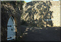
Lane junction, Townstal
Keep Lane (ahead left) and Mount Boone Lane (right) leave Townstal Hill between high walls. On the left is an arched doorway in the extensive boundary wall to The Keep, a castle-like structure described at https://historicengland.org.uk/listing/the-list/list-entry/1197501 ; the text includes a reference to "good original ferramenta", although it is uncertain whether this particular door is included.
Image: © Derek Harper
Taken: 27 Sep 2020
0.06 miles
9
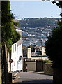
Clarence Hill, Dartmouth
The top of Clarence Hill, seen from Townstal Hill, with the junction with Vicarage Hill on the right. Behind and below are the Dart and Kingswear.
Image: © Derek Harper
Taken: 27 Sep 2009
0.06 miles