IMAGES TAKEN NEAR TO
Prideaux Lane, DARTMOUTH, TQ6 0SA
Introduction
This page details the photographs taken nearby to Prideaux Lane, TQ6 0SA by members of the Geograph project.
The Geograph project started in 2005 with the aim of publishing, organising and preserving representative images for every square kilometre of Great Britain, Ireland and the Isle of Man.

There are currently over 7.5m images from over14,400 individuals and you can help contribute to the project by visiting https://www.geograph.org.uk
Image Map
Images are licensed for reuse under creativecommons.org/licenses/by-sa/2.0
Notes
- Clicking on the map will re-center to the selected point.
- The higher the marker number, the further away the image location is from the centre of the postcode.
Image Listing (109 Images Found)
Images are licensed for reuse under creativecommons.org/licenses/by-sa/2.0
Image
Details
Distance
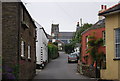
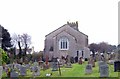
2
St Michael's Church, Strete
The church is in the United Benefice of Stoke Fleming, Blackawton and Strete.
It is at the intersection of four grid squares. Other pictures can be found in Image and Image
Image: © Robin Drayton
Taken: 28 Apr 2010
0.02 miles
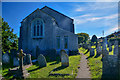
3
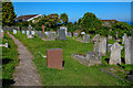
Strete : St Michael's Church
Headstones and a path head through the churchyard.
Image: © Lewis Clarke
Taken: 30 Jul 2020
0.02 miles
4
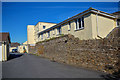
Strete : Hyne Town House
Looking along a driveway into the premises.
Image: © Lewis Clarke
Taken: 30 Jul 2020
0.03 miles
5
Strete Church
The eastern end of the church at Strete
Image: © Paul Hutchinson
Taken: 13 Nov 2008
0.03 miles
6
Strete : St Michael's Church
Looking towards St Michael's Church.
Image: © Lewis Clarke
Taken: 30 Jul 2020
0.03 miles
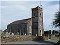
7
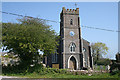
Strete: St Michael's church
The church was completed in 1836. The parish of Strete was created in 1881; previously it was part of Blackawton
Image: © Martin Bodman
Taken: 18 Apr 2011
0.03 miles
8
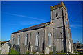
Strete : St Michael's Church
The parish of Strete was created out of the south-eastern part of Blackawton parish in 1881. There was a small medieval chapel of ease in the village until 1836 when the present church, dedicated to St Michael, was built on the same site, incorporating the chapel's tower.
Image: © Lewis Clarke
Taken: 30 Jul 2020
0.03 miles
9
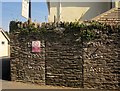
Wall, Strete
Evidence of a door gate in this wall on Totnes Road, with some layers of cobbles within the slate on either side of the former opening.
Image: © Derek Harper
Taken: 9 Sep 2014
0.03 miles
10
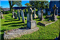
Strete : St Michael's Church
Looking towards headstones in the churchyard.
Image: © Lewis Clarke
Taken: 30 Jul 2020
0.03 miles