IMAGES TAKEN NEAR TO
Shady Lane, DARTMOUTH, TQ6 0PB
Introduction
This page details the photographs taken nearby to Shady Lane, TQ6 0PB by members of the Geograph project.
The Geograph project started in 2005 with the aim of publishing, organising and preserving representative images for every square kilometre of Great Britain, Ireland and the Isle of Man.

There are currently over 7.5m images from over14,400 individuals and you can help contribute to the project by visiting https://www.geograph.org.uk
Image Map (Loading...)


Getting Data...Please wait
Leaflet Map data © OpenStreetMap
Images are licensed for reuse under creativecommons.org/licenses/by-sa/2.0
Notes
- Clicking on the map will re-center to the selected point.
- The higher the marker number, the further away the image location is from the centre of the postcode.
Image Listing (100 Images Found)
Images are licensed for reuse under creativecommons.org/licenses/by-sa/2.0
Image
Details
Distance
1
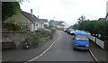
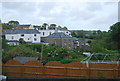
Stoke Fleming
This is the A379 from Dartmouth to Kingsbridge. It gets a bit narrow within this village and is the cause of some summer traffic slow downs.
Image: © Richard Knights
Taken: 5 Jul 2005
0.05 miles
2

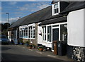
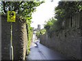
Old Well Site, Stoke Fleming
In Shady Lane, restored 2000 - 2001
Image: © Rick Crowley
Taken: 7 Feb 2023
0.13 miles
5
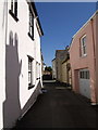
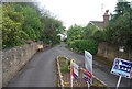
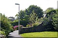
Chapel Lane, Stoke Fleming
The chimney stack and cowls of the house opposite cast a curious shadow on a wall at the entrance to this little cul-de-sac off the A379.
Image: © Derek Harper
Taken: 25 Aug 2007
0.14 miles