IMAGES TAKEN NEAR TO
Venn, DARTMOUTH, TQ6 0LF
Introduction
This page details the photographs taken nearby to TQ6 0LF by members of the Geograph project.
The Geograph project started in 2005 with the aim of publishing, organising and preserving representative images for every square kilometre of Great Britain, Ireland and the Isle of Man.

There are currently over 7.5m images from over14,400 individuals and you can help contribute to the project by visiting https://www.geograph.org.uk
Image Map
Images are licensed for reuse under creativecommons.org/licenses/by-sa/2.0
Notes
- Clicking on the map will re-center to the selected point.
- The higher the marker number, the further away the image location is from the centre of the postcode.
Image Listing (5 Images Found)
Images are licensed for reuse under creativecommons.org/licenses/by-sa/2.0
Image
Details
Distance
1
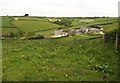
Thorn Farm
A common farm name in Devon. This one has been the subject of considerable conversions, although the corrugated iron barn on the hillside to the left (in Image) has so far escaped renovation. The valley is one of several that join to lead down to the sea at Blackpool.
Image: © Derek Harper
Taken: 23 May 2009
0.05 miles
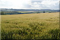
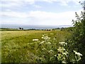
4
Rolling Devon fields near Dartmouth
Viewed from the A379 looking west in evening light.
Image: © Bill Boaden
Taken: 22 Jun 2011
0.22 miles
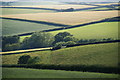
5
South of Dartmouth
The roadside view just outside of Dartmouth. Far in the distance is Start Point.
Image: © Richard Knights
Taken: 5 Jul 2005
0.24 miles