IMAGES TAKEN NEAR TO
DARTMOUTH, TQ6 0LB
Introduction
This page details the photographs taken nearby to TQ6 0LB by members of the Geograph project.
The Geograph project started in 2005 with the aim of publishing, organising and preserving representative images for every square kilometre of Great Britain, Ireland and the Isle of Man.

There are currently over 7.5m images from over14,400 individuals and you can help contribute to the project by visiting https://www.geograph.org.uk
Image Map (Loading...)


Getting Data...Please wait
Leaflet Map data © OpenStreetMap
Images are licensed for reuse under creativecommons.org/licenses/by-sa/2.0
Notes
- Clicking on the map will re-center to the selected point.
- The higher the marker number, the further away the image location is from the centre of the postcode.
Image Listing (13 Images Found)
Images are licensed for reuse under creativecommons.org/licenses/by-sa/2.0
Image
Details
Distance
1
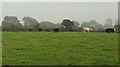
Cattle, Cotton
Seen from the same spot as Image], looking right.
Image: © Derek Harper
Taken: 26 Sep 2017
0.13 miles
2
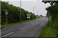
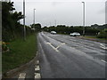
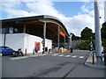
Road signs on the edge of Dartmouth
The main feature here is the new Sainsbury's on the edge of town. One of the signs says town centre parking is 4 hour maximum, but it is possible to park for longer than that.
Image: © Bill Boaden
Taken: 25 Jun 2011
0.14 miles
3
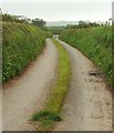
Venn Lane
Looking in the opposite direction from where Image] was taken.
Image: © Derek Harper
Taken: 26 Sep 2017
0.17 miles
4
View near Cotton
Little Cotton Caravan Park is in the left background, across a valley leading from the western edge of Dartmouth into the Blackpool valley. Seen from the end of the farm road leading to Little and Great Cotton.
Image: © Derek Harper
Taken: 23 Jun 2006
0.17 miles
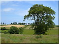
6
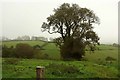
Farmland, Cotton
With a dominant tree on the line of a former field boundary. The valley drains to join the Blackpool valley.
Image: © Derek Harper
Taken: 26 Sep 2017
0.18 miles
7
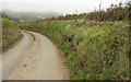
Venn Lane
Curving between hedgebanks towards the junction with the A3122. Ahead in the mist are Norton Park Chalets and farm.
Image: © Derek Harper
Taken: 26 Sep 2017
0.20 miles
8
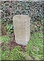
Old Milestone, A3122, Totnes Road, Townstal, Dartmouth
The milestone is located 80m west of the Park & Ride, 20m East of the turn to Sainsbury's supermarket, on the grass verge on the south side of the road. Parish of Dartmouth (South Hams District). Carved stone post, Kingsbridge granite triangle design, erected by the Kingsbridge & Dartmouth turnpike trust in the 19th century.
Inscription reads:-
: To / Kings / bridge / 12 / Modby / 14 / Totnes / 11 : : To / Dart / mouth / 2 :
Grade II listed. List Entry Number: 1218150
https://historicengland.org.uk/listing/the-list/list-entry/1218150
Milestone Society National ID: DV_DMKB02
Image: © Alan Rosevear
Taken: 22 Feb 2013
0.21 miles
9

Sainsbury's in Dartmouth
A new supermarket but it is right on the edge of town and at the top of the hill, so it shouldn't affect business in the town centre very much. The town centre still has a Spar and a Co-op.
Image: © Bill Boaden
Taken: 22 Jun 2011
0.22 miles
10
New Out of Town Supermarket - Dartmouth
Image: © Anthony Parkes
Taken: 30 May 2011
0.22 miles