IMAGES TAKEN NEAR TO
Orchard Park, The Level, DARTMOUTH, TQ6 0ET
Introduction
This page details the photographs taken nearby to Orchard Park, The Level, TQ6 0ET by members of the Geograph project.
The Geograph project started in 2005 with the aim of publishing, organising and preserving representative images for every square kilometre of Great Britain, Ireland and the Isle of Man.

There are currently over 7.5m images from over14,400 individuals and you can help contribute to the project by visiting https://www.geograph.org.uk
Image Map
Images are licensed for reuse under creativecommons.org/licenses/by-sa/2.0
Notes
- Clicking on the map will re-center to the selected point.
- The higher the marker number, the further away the image location is from the centre of the postcode.
Image Listing (148 Images Found)
Images are licensed for reuse under creativecommons.org/licenses/by-sa/2.0
Image
Details
Distance
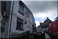
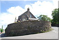
1
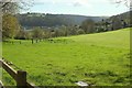
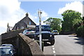
Shinners Meadow, Dittisham
On the right is the football pitch used by Dittisham United. The field slopes down towards the Ham. Across the river are the wooded grounds of Greenway House, and Long Wood on the right. View from Riverside Road.
Image: © Derek Harper
Taken: 2 Apr 2017
0.02 miles
4
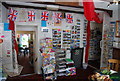
Village shop, Dittisham
Inside the Red Lion pub.
Image: © N Chadwick
Taken: 6 Jun 2012
0.04 miles
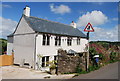
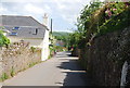
5
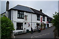
The Red Lion Inn, Dittisham
A community pub which also incorporates the post office and shop.
Image: © Bill Boaden
Taken: 25 Jun 2011
0.04 miles
9
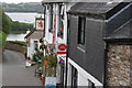
The Red Lion
Local pub which also doubles as the village shop and Post Office
Image: © Simon Palmer
Taken: 19 May 2011
0.04 miles