IMAGES TAKEN NEAR TO
Wood Lane, DARTMOUTH, TQ6 0DG
Introduction
This page details the photographs taken nearby to Wood Lane, TQ6 0DG by members of the Geograph project.
The Geograph project started in 2005 with the aim of publishing, organising and preserving representative images for every square kilometre of Great Britain, Ireland and the Isle of Man.

There are currently over 7.5m images from over14,400 individuals and you can help contribute to the project by visiting https://www.geograph.org.uk
Image Map
Images are licensed for reuse under creativecommons.org/licenses/by-sa/2.0
Notes
- Clicking on the map will re-center to the selected point.
- The higher the marker number, the further away the image location is from the centre of the postcode.
Image Listing (58 Images Found)
Images are licensed for reuse under creativecommons.org/licenses/by-sa/2.0
Image
Details
Distance
1
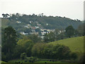
Housing at Kingswear
A view of housing at Kingswear from the Brixham Road.
Image: © Tom Jolliffe
Taken: 15 Oct 2011
0.03 miles
2
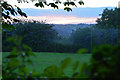
Kingswear : Grassy Field
A grassy field on the Kingswear outskirts.
Image: © Lewis Clarke
Taken: 9 Aug 2016
0.07 miles
3
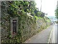
Blocked off postbox in wall, edge of Kingswear
Image: © David Smith
Taken: 11 Jun 2021
0.07 miles
4
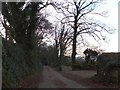
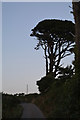
Trees lining Mount Ridley Road
This is on the eastern edge of Kingswear. Mount Ridley Road follows a ridge between valleys to Boohay and Nethway. The hedgebanks indicate that the road has run this way for many decades or longer.
Image: © David Smith
Taken: 11 Dec 2013
0.07 miles
5
South Hams : Mount Ridley Road
Looking along the road as it heads out from Kingswear.
Image: © Lewis Clarke
Taken: 9 Aug 2016
0.10 miles
6
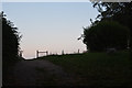
Kingswear : Grassy Field
A grassy field and track.
Image: © Lewis Clarke
Taken: 9 Aug 2016
0.11 miles
8
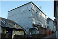
House under scaffolding, Kingswear
Near the top of Wood Lane.
Image: © Derek Harper
Taken: 26 Mar 2017
0.12 miles
9
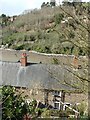
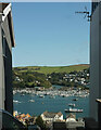
Kingswear
Looking down to the houses from the "higher" road
Image: © Snidge
Taken: 18 Mar 2007
0.12 miles
10
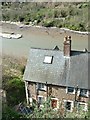
Waterhead Creek and Kingswear from Jawbones Hill
A glimpse between two houses across the River Dart.
Image: © Derek Harper
Taken: 13 Sep 2020
0.13 miles